Ždírec | |
|---|---|
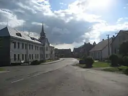
 Retirement home by the main road | |
 Flag  Coat of arms | |
 Ždírec Location in the Czech Republic | |
| Coordinates: 49°27′18″N 15°40′43″E / 49.45500°N 15.67861°E | |
| Country | |
| Region | Vysočina |
| District | Jihlava |
| First mentioned | 1233 |
| Area | |
| • Total | 10.37 km2 (4.00 sq mi) |
| Elevation | 515 m (1,690 ft) |
| Population (2023-01-01)[1] | |
| • Total | 443 |
| • Density | 43/km2 (110/sq mi) |
| Time zone | UTC+1 (CET) |
| • Summer (DST) | UTC+2 (CEST) |
| Postal code | 588 13 |
| Website | www |
Ždírec (German: Seelenz) is a municipality and village in Jihlava District in the Vysočina Region of the Czech Republic. It has about 400 inhabitants.
Geography
Ždírec lies about 8 kilometres (5 mi) northeast of Jihlava. It is located in the Upper Sázava Hills. The highest point is at 552 m (1,811 ft) above sea level. The Ždírecký Stream flows through the municipality. There are several small fish ponds on the stream.
History

The first written mention of Ždírec is from 1233. From the 13th century until 1945 Ždírec was ethnically a German village. It belonged to the German-speaking enclave called Jihlava Language Island. After World War II, the Germans were expelled and the municipality was resettled by Czechs.[2]
Sights
The main landmark of Ždírec is the Church of Saint Wenceslaus. It was built in the pseudo-Gothic style in 1893–1898, after the old church was destroyed by a fire in 1890. It became protected as a cultural monument in 1958.[2]
Other sights include Baroque sculptural group of Saint John of Nepomuk from 1743, Baroque statue of Anthony of Padua from 1753, and the building of retirement home from 1926 with Chapel of the Virgin Mary.[2]
References
- ↑ "Population of Municipalities – 1 January 2023". Czech Statistical Office. 2023-05-23.
- 1 2 3 "Strategický rozvojový plán obce Ždírec na období let 2019–2022" (in Czech). Obec Ždírec. pp. 2, 11. Retrieved 2022-04-25.