Radkov | |
|---|---|
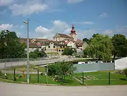 View towards the Church of Saint Bartholomew | |
 Radkov Location in the Czech Republic | |
| Coordinates: 49°8′43″N 15°28′31″E / 49.14528°N 15.47528°E | |
| Country | |
| Region | Vysočina |
| District | Jihlava |
| First mentioned | 1358 |
| Area | |
| • Total | 6.28 km2 (2.42 sq mi) |
| Elevation | 488 m (1,601 ft) |
| Population (2023-01-01)[1] | |
| • Total | 238 |
| • Density | 38/km2 (98/sq mi) |
| Time zone | UTC+1 (CET) |
| • Summer (DST) | UTC+2 (CEST) |
| Postal code | 588 56 |
| Website | www |
Radkov (Czech pronunciation: [ˈratkof]) is a municipality and village in Jihlava District in the Vysočina Region of the Czech Republic. It has about 200 inhabitants.
Radkov lies approximately 29 kilometres (18 mi) south of Jihlava and 130 km (81 mi) south-east of Prague.
References
Wikimedia Commons has media related to Radkov (Jihlava District).
This article is issued from Wikipedia. The text is licensed under Creative Commons - Attribution - Sharealike. Additional terms may apply for the media files.