Highway 33 | ||||
|---|---|---|---|---|
| Grizzly Trail | ||||
 | ||||
| Route information | ||||
| Maintained by Alberta Ministry of Transportation | ||||
| Length | 218.6 km[1] (135.8 mi) | |||
| Major junctions | ||||
| South end | ||||
| North end | ||||
| Location | ||||
| Country | Canada | |||
| Province | Alberta | |||
| Specialized and rural municipalities | Lac Ste. Anne County, County of Barrhead No. 11, Woodlands County, Big Lakes County | |||
| Towns | Barrhead, Swan Hills | |||
| Highway system | ||||
|
| ||||
| ||||

.png.webp)
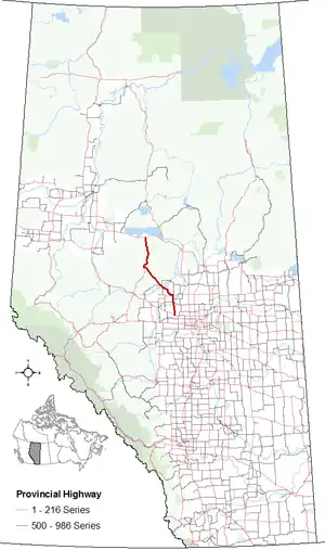
Alberta Provincial Highway No. 33, commonly referred to as Highway 33 and officially named Grizzly Trail, is a north–south highway in west–central Alberta, Canada.
Highway 33 begins at Highway 43 near the hamlet of Gunn and travels north to the town of Barrhead. North of Barrhead, Highway 33 turns northwest, crossing the Athabasca River at Fort Assiniboine, before reaching the town of Swan Hills. Highway 33 continues north from Swan Hills to Highway 2 east of Kinuso. Highway 33 is about 219 kilometres (136 mi) in length.[1][2]
History
Highway 33 follows the original Klondike Trail, which was advertised by Edmonton merchants as the shortest route to the Yukon during the Klondike Gold Rush, from the Athabasca River at Pruden's Crossing, near Fort Assiniboine, through present-day Swan Hills and along the Swan River to north to present-day Kinuso. The trail followed a very difficult and dangerous route and by 1901-02 use of the trail declined, soon after it was abandoned altogether in favour of other routes to the Peace River area.[3][4]
Highway 33 originally started as short highway that connected Highway 43, 7 km (4 mi) south of Onoway, to Alberta Beach.[5] In the 1970s, Highway 33 was extended north to Barrhead from Gunn, resulting in an 8 km (5 mi) gap between Alberta Beach and Gunn.[6] Highway 18, which ran between Barrhead and Swan Hills, was renumbered to Highway 33 and the highway was extended north to Kinuso.[7] In c. 1985, the original section to Alberta Beach became part of Highway 633.[8][9]
Major intersections
From south to north:
| Rural/specialized municipality | Location | km[1] | mi | Destinations | Notes | ||
|---|---|---|---|---|---|---|---|
| Lac Ste. Anne County | | −18.7 | −11.6 | South of Onoway; former eastern terminus | |||
| −10.6 | −6.6 | Former Hwy 634 | |||||
| Alberta Beach | −8.1 | −5.0 | Former western terminus | ||||
| 8 km (5 mi) gap | |||||||
| | 0.0 | 0.0 | East of Gunn | ||||
| Rich Valley | 13.5 | 8.4 | |||||
| Birch Cove | 25.8 | 16.0 | |||||
| County of Barrhead No. 11 | | 28.0 | 17.4 | ||||
| 30.0 | 18.6 | Crosses the Pembina River | |||||
| 31.9 | 19.8 | South end of Hwy 654 concurrency | |||||
| 38.3 | 23.8 | North end of Hwy 654 concurrency | |||||
| Barrhead | 44.8 | 27.8 | South end of Hwy 18 concurrency | ||||
| | 48.0 | 29.8 | Hwy 33 branches west; north end of Hwy 18 concurrency | ||||
| Camp Creek | 66.9 | 41.6 | |||||
| | 79.7 | 49.5 | |||||
| ↑ / ↓ | | 82.3 | 51.1 | Crosses the Athabasca River | |||
| Woodlands County | Fort Assiniboine | 83.9 | 52.1 | Hwy 33 branches northwest | |||
| | 91.1 | 56.6 | |||||
| Big Lakes County | Swan Hills | 145.2 | 90.2 | Hwy 33 branches north | |||
| | 218.6 | 135.8 | East of Kinuso | ||||
1.000 mi = 1.609 km; 1.000 km = 0.621 mi
| |||||||
Photos
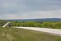 Highway 33 north of Swan Hills
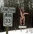 Junction sign on Highway 43
References
- 1 2 3 Google (2017-12-18). "Highway 33 in Alberta" (Map). Google Maps. Google. Retrieved 2017-12-18.
- ↑ "2015 Provincial Highway 1-216 Progress Chart" (PDF). Alberta Transportation. March 2015. Archived (PDF) from the original on 2016-04-10. Retrieved 2016-10-12.
- ↑ "History of Barrhead". Town of Barrhead. Archived from the original on May 20, 2018. Retrieved May 20, 2018.
- ↑ Thome, Michael (2012-07-19). "Klondike Trail". RETROactive. Government of Alberta. Retrieved 2018-05-20.
- ↑ The H.M. Gousha Company (1956). Shell Map of British Columbia, Alberta, Saskatchewan, and Manitoba (Map). The Shell Oil Company. § C-12.
- ↑ Travel Alberta (1976–1977). Alberta Official Road Map (Map). The Province of Alberta. §§ H-4, H-5, I-5.
- ↑ Travel Alberta (1978–1979). Alberta Official Road Map (Map). The Province of Alberta. §§ H-4, H-5, I-5.
- ↑ Province of Alberta Canada 1985 Official Road Map (Map). Alberta Tourism and Small Business. § I-5.
- ↑ Province of Alberta Canada 1986 Official Road Map (Map). Alberta Tourism and Small Business. § I-5.