Highway 64 | ||||
|---|---|---|---|---|
 Highway 64 highlighted in red | ||||
| Route information | ||||
| Maintained by Alberta Ministry of Transportation | ||||
| Length | 126.03 km[1] (78.31 mi) | |||
| Major junctions | ||||
| West end | British Columbia border | |||
| East end | ||||
| Location | ||||
| Country | Canada | |||
| Province | Alberta | |||
| Specialized and rural municipalities | Clear Hills County, Fairview No. 136 M.D. | |||
| Villages | Hines Creek | |||
| Highway system | ||||
|
| ||||
| ||||

Alberta Provincial Highway No. 64[2] is an east-west highway in northern Alberta, Canada. In the west, Highway 64 begins at the Alberta/British Columbia border and ends at Highway 2 southwest of the Town of Fairview.[1][3]
Major intersections
| Rural/specialized municipality | Location | km | mi | Destinations | Notes |
|---|---|---|---|---|---|
| Clear Hills County | | 0.0 | 0.0 | Cecil Lake Road (Hwy 103 west) – Cecil Lake, Fort St. John | Continues into British Columbia; Hwy 103 is an unofficial route (unsigned) |
| | 12.1 | 7.5 | |||
| | 57.5 | 35.7 | |||
| | 83.7 | 52.0 | |||
| Hines Creek | 97.7 | 60.7 | |||
| M.D. of Fairview No. 136 | | 119.3 | 74.1 | ||
| | 126.0 | 78.3 | |||
| 1.000 mi = 1.609 km; 1.000 km = 0.621 mi | |||||
Highway 64A
Highway 64A | |
|---|---|
| Location | M.D. of Fairview No. 136, Town of Fairview |
| Length | 6.64 km[1] (4.13 mi) |
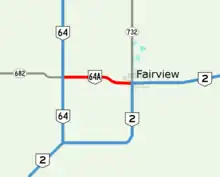
Highway 64A in Fairview, Alberta
Alberta Provincial Highway No. 64A is the designation of an alternate route off Highway 64 serving the Town of Fairview. It extends 7 km (4.3 mi) from its intersection with Highway 64/Highway 682 in the west to its intersection with Highway 2/Highway 732 within Fairview in the east.[3]
Major intersections
| Location | mi | km | Destinations | Notes | |
|---|---|---|---|---|---|
| M.D. of Fairview No. 136 | 0.00 | 0.00 | Western terminus; continues as Hwy 682 west | ||
| Fairview | 6.64 | 4.13 | Eastern terminus; continues as Hwy 2 north | ||
| 1.000 mi = 1.609 km; 1.000 km = 0.621 mi | |||||
References
- 1 2 3 "Provincial Highway 1-216 Progress Chart" (PDF). Alberta Transportation. March 2015. Archived (PDF) from the original on April 10, 2016. Retrieved October 31, 2016.
- ↑ Provincial Highways Designation Order, Alberta Transportation, p. 9
- 1 2 Google (June 16, 2021). "Highway 64/64A in northern Alberta" (Map). Google Maps. Google. Retrieved June 16, 2021.
This article is issued from Wikipedia. The text is licensed under Creative Commons - Attribution - Sharealike. Additional terms may apply for the media files.