Ando
安堵町 | |
|---|---|
Town | |
 Flag  Emblem | |
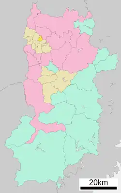
 Location of Ando in Nara Prefecture | |
 Ando Location in Japan | |
| Coordinates: 34°36′N 135°45′E / 34.600°N 135.750°E | |
| Country | Japan |
| Region | Kansai |
| Prefecture | Nara Prefecture |
| District | Ikoma |
| Area | |
| • Total | 4.33 km2 (1.67 sq mi) |
| Population (April 1, 2017) | |
| • Total | 7,523 |
| • Density | 1,700/km2 (4,500/sq mi) |
| Time zone | UTC+09:00 (JST) |
| City hall address | 958 Higashi-ando, Ando-chō, Ikoma-gun, Nara-ken 639-1095 |
| Website | www |
| Symbols | |
| Flower | Dianthus |
| Tree | Ilex integra |
Ando (安堵町, Ando-chō) is a town located in Ikoma District, Nara Prefecture, Japan.
As of April 1, 2017, the town has an estimated population of 7,523 and 3,395 households.[1] The density is 1700 persons per km², and the total area is 4.33 km².
Geography
Located in the northwestern portion of Nara Prefecture, it is a relatively small town situated close to the center of the Nara Basin. The Tomio River and Yamato River flow through Ando.
History
- 1889 - Five villages are merged in Heguri District, creating Ando village.
- 1896 - Heguri District is united by Soejimo District, creating Ikoma District.
- 1986 - Ando village is renamed Ando town.
Education
- Primary Schools
- Ando Elementary School
- Junior High Schools
- Ando Junior High School
Places of note
- Ando Cultural Museum
- Tomimoto Kenichi Memorial Museum
- Nakake House
Transportation
Rail
West Japan Railway Company's Kansai Main Line (Yamatoji Line) passes through Ando. However, no stations are found in the town.
Road
References
- ↑ "Official website of Ando Town" (in Japanese). Japan: Ando Town. Retrieved 24 April 2017.
External links
 Media related to Ando, Nara at Wikimedia Commons
- Ando official website (in Japanese)
This article is issued from Wikipedia. The text is licensed under Creative Commons - Attribution - Sharealike. Additional terms may apply for the media files.