| Yamato River | |
|---|---|
 | |
| Native name | 大和川 (Japanese) |
| Location | |
| Country | Japan |
| Region | Kansai region |
| Physical characteristics | |
| Source | |
| • location | Kaikira-yama, Nara Prefecture |
| • elevation | 822 m (2,697 ft) |
| Mouth | Osaka Bay |
• coordinates | 34°36′30″N 135°26′28″E / 34.6084°N 135.4410°E |
| Length | 68 km (42 mi) |

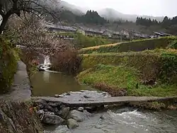
River in Sakurai, Nara Prefecture.
The Yamato River (大和川, Yamato-gawa) is a river which flows through Nara Prefecture and Osaka Prefecture, Japan. It is designated Class A by the Ministry of Land, Infrastructure, Transport and Tourism (MLIT).
The river flows via towns:
Since 1704 the river was reconfigured, originally its flow was north from the Ishikawa River confluence point, where it joined the Shirinashi River and Kizu River.[1]
At the river mouth is a densely populated area and the river forms a natural border between Osaka and Sakai.[2]
See also
Wikimedia Commons has media related to Yamato River.
References
- ↑ "Yamato River". Retrieved 28 March 2017.
- ↑ Davidson, Neil (4 January 2014). "Yamato River, Osaka". Retrieved 28 March 2017.
Article contains translated text from 大和川 on the Japanese Wikipedia retrieved on 26 March 2017.
This article is issued from Wikipedia. The text is licensed under Creative Commons - Attribution - Sharealike. Additional terms may apply for the media files.