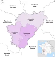
Map of arrondissements of the Charente department.
The 3 arrondissements of the Charente department are:[1]
- Arrondissement of Angoulême, (prefecture of the Charente department: Angoulême) with 115 communes.[2] The population of the arrondissement was 181,456 in 2016.
- Arrondissement of Cognac, (subprefecture: Cognac) with 110 communes.[3] The population of the arrondissement was 99,987 in 2016.
- Arrondissement of Confolens, (subprefecture: Confolens) with 140 communes.[4] The population of the arrondissement was 71,845 in 2016.
History
In 1800 the arrondissements of Angoulême, Barbezieux, Cognac, Confolens and Ruffec were established. The arrondissements of Barbezieux and Ruffec were disbanded in 1926.[5] On 1 January 2008 the four cantons of Aigre, Mansle, Ruffec and Villefagnan that previously belonged to the arrondissement of Angoulême were added to the arrondissement of Confolens, and the canton of Rouillac to the arrondissement of Cognac.[5][6]
The borders of the arrondissements of Charente were modified in January 2017:[7]
- 14 communes from the arrondissement of Angoulême to the arrondissement of Cognac
- 15 communes from the arrondissement of Angoulême to the arrondissement of Confolens
- two communes from the arrondissement of Cognac to the arrondissement of Angoulême
References
- ↑ "Populations légales 2016" (PDF). INSEE. December 2018. Retrieved 2019-10-23.
- ↑ "Arrondissement d'Angoulême (161)". INSEE. Retrieved 2019-09-27.
- ↑ "Arrondissement de Cognac (162)". INSEE. Retrieved 2019-09-27.
- ↑ "Arrondissement de Confolens (163)". INSEE. Retrieved 2019-09-27.
- 1 2 Historique de la Charente
- ↑ "Modification des limites d'arrondissement". Archived from the original on 2007-12-25. Retrieved 2019-10-23.
- ↑ "Arrêté préfectoral, 30 December 2016" (PDF). pp. 98–108. Retrieved 2019-10-08.
This article is issued from Wikipedia. The text is licensed under Creative Commons - Attribution - Sharealike. Additional terms may apply for the media files.