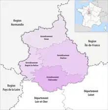
Map of arrondissements of the Eure-et-Loir department.
The 4 arrondissements of the Eure-et-Loir department are:[1]
- Arrondissement of Chartres, (prefecture of the Eure-et-Loir department: Chartres) with 148 communes.[2] The population of the arrondissement was 209,218 in 2016.
- Arrondissement of Châteaudun, (subprefecture: Châteaudun) with 61 communes.[3] The population of the arrondissement was 59,262 in 2016.
- Arrondissement of Dreux, (subprefecture: Dreux) with 108 communes. The population of the arrondissement was 129,414 in 2016.
- Arrondissement of Nogent-le-Rotrou, (subprefecture: Nogent-le-Rotrou) with 48 communes.[4] The population of the arrondissement was 36,035 in 2016.
History
In 1800 the arrondissements of Chartres, Châteaudun, Dreux and Nogent-le-Rotrou were established. The arrondissement of Nogent-le-Rotrou was disbanded in 1926, and restored in 1943.[5]
References
- ↑ "Populations légales 2016" (PDF). INSEE. December 2018. Retrieved 2019-10-24.
- ↑ "Arrondissement de Chartres (281)". INSEE. Retrieved 2019-09-29.
- ↑ "Arrondissement de Châteaudun (282)". INSEE. Retrieved 2019-09-29.
- ↑ "Arrondissement de Nogent-le-Rotrou (284)". INSEE. Retrieved 2019-09-29.
- ↑ Historique d'Eure-et-Loir
This article is issued from Wikipedia. The text is licensed under Creative Commons - Attribution - Sharealike. Additional terms may apply for the media files.