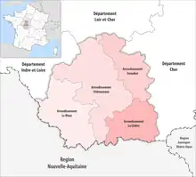
Map of arrondissements of the Indre department.
The 4 arrondissements of the Indre department are:[1]
- Arrondissement of Le Blanc, (subprefecture: Le Blanc) with 57 communes. The population of the arrondissement was 31,714 in 2016.
- Arrondissement of Châteauroux, (prefecture of the Indre department: Châteauroux) with 84 communes.[2] The population of the arrondissement was 129,106 in 2016.
- Arrondissement of La Châtre, (subprefecture: La Châtre) with 51 communes. The population of the arrondissement was 28,433 in 2016.
- Arrondissement of Issoudun, (subprefecture: Issoudun) with 49 communes. The population of the arrondissement was 34,252 in 2016.
History
In 1800 the arrondissements of Châteauroux, Le Blanc, La Châtre and Issoudun were established. The arrondissement of Issoudun was disbanded in 1926, and restored in 1942.[3]
The borders of the arrondissements of Indre were modified in January 2017:[4]
- one commune from the arrondissement of Châteauroux to the arrondissement of Le Blanc
- one commune from the arrondissement of Châteauroux to the arrondissement of La Châtre
- eight communes from the arrondissement of La Châtre to the arrondissement of Châteauroux
References
- ↑ "Populations légales 2016" (PDF). INSEE. December 2018. Retrieved 2019-10-24.
- ↑ "Arrondissement de Châteauroux (362)". INSEE. Retrieved 2019-09-30.
- ↑ Historique de l'Indre
- ↑ "Arrêté préfectoral, 15 December 2016" (PDF). pp. 91–93. Retrieved 2019-10-21.
This article is issued from Wikipedia. The text is licensed under Creative Commons - Attribution - Sharealike. Additional terms may apply for the media files.