| Barronette Peak | |
|---|---|
 1977 | |
| Highest point | |
| Elevation | 10,354 ft (3,156 m)[1] |
| Coordinates | 44°58′31″N 110°05′19″W / 44.97528°N 110.08861°W[1] |
| Geography | |
| Location | Yellowstone National Park, Park County, Wyoming |
| Parent range | Absaroka Range |
| Topo map | Abiathar Peak |
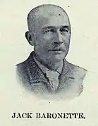
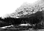
Barronette Peak, elevation 10,354 feet (3,156 m), is a mountain peak in the Absaroka Range, in the northeast section of Yellowstone National Park. The peak is named for Collins Jack (John H. "Yellowstone Jack") Baronette (1829–1901). It was named by the Hayden Geological Survey of 1878, which misspelled it as Barronette; the peak retains the official misspelled name today.[2]
Jack Baronette was an early Yellowstone guide and entrepreneur. He built and operated the first bridge across the Yellowstone River near the confluence of the Lamar River in 1871 to service miners traveling to Cooke City, Montana. In 1870, as a resident of Helena, Montana, he participated in the search for and rescue of Truman C. Everts, lost during the Washburn–Langford–Doane Expedition of 1870. In 1884, he was considered for the superintendency of Yellowstone.[3]
 Barronette Peak's namesake, Jack Baronette
 Barronette Peak, ca 1890
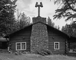
 January, 2010
 Barronette Peak panorama
See also
Notes
- 1 2 "Barronette Peak". Geographic Names Information System. United States Geological Survey, United States Department of the Interior.
- ↑ Whittlesey, Lee (1988). Yellowstone Place Names. Helena, MT: Montana Historical Society Press. p. 19. ISBN 0-917298-15-2.
- ↑ Culpin, Mary Shivers (2003). For the Benefit and Enjoyment of the People: A History of Concession Development in Yellowstone National Park-1872-1966. Yellowstone National Park, WY: Yellowstone Center for Resources.
