Flag of Belo Monte
Coat of arms of Belo Monte
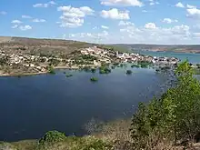
Belo Monte is a municipality located in the western of the Brazilian state of Alagoas. Its population is 6,710 (2020)[1] and its area is 334 km².[2]
The municipality was designated a priority area for conservation and sustainable use when the Caatinga Ecological Corridor was created in 2006.[3]
References
- ↑ IBGE 2020
- ↑ IBGE - "Archived copy". Archived from the original on 2007-01-09. Retrieved 2014-08-03.
{{cite web}}: CS1 maint: archived copy as title (link) - ↑ Mattos, Marluza (2006), Ministério cria Corredor Ecológico da Caatinga (in Portuguese), Ministério do Meio Ambiente, retrieved 2016-11-01
09°49′40″S 37°16′48″W / 9.82778°S 37.28000°W
Capital: Maceió | ||
| Arapiraca | 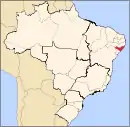 | |
| Palmeira dos Índios | ||
| Traipu | ||
| Litoral Norte Alagoano | ||
| Maceió | ||
| Mata Alagoana | ||
| Penedo | ||
| São Miguel dos Campos | ||
| Serrana dos Quilombos | ||
| Alagoana do Sertão do São Francisco | ||
| Batalha | ||
| Santana do Ipanema | ||
| Serrana do Sertão Alagoano | ||
This article is issued from Wikipedia. The text is licensed under Creative Commons - Attribution - Sharealike. Additional terms may apply for the media files.