Bireuën Regency
Kabupaten Bireuën | |
|---|---|
|
Seal | |
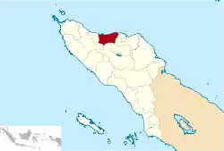 Location within Aceh | |
| Coordinates: 5°5′N 96°36′E / 5.083°N 96.600°E | |
| Country | |
| Region | Sumatra |
| Province | |
| Established | 1999 |
| Regency seat | Bireuën |
| Government | |
| • Regent | Dr. H. Muzakkar A. Gani, S.H., M.Si |
| Area | |
| • Total | 1,798.25 km2 (694.31 sq mi) |
| Population (mid 2022 estimate)[1] | |
| • Total | 443,874 |
| • Density | 250/km2 (640/sq mi) |
| Time zone | UTC+7 (IWST) |
| Area code | (+62) 644 |
| Website | bireunkab.go.id |
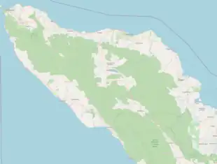

Bireuën Regency (Indonesian: Kabupaten Bireuen) is a regency of Aceh, the westernmost province of Indonesia. It is located on the island of Sumatra. The capital is Bireuën, 105 miles east of the provincial capital, Banda Aceh. The regency covers an area of 1,798.25 square kilometres and had a population of 340,271 people according to the 2000 Census;[2] at the 2010 Census it had a population of 389,288,[3] which had risen to 436,418 at the 2020 Census;[4] the official estimate as at mid 2022 was 443,874 - comprising 219,039 males and 224,835 females.[1] It is bordered by the Strait of Malacca on the northeast coastline. Bireuen has been affected by the clashes between the Free Aceh Movement (GAM) and the government, and by the Indian Ocean earthquake and tsunami on 26 December 2004.
The regency's name is commonly spelled without the diaeresis on the letter Ë: Kabupaten Bireuen (in Acehnese, Ë represents a schwa ([ə]) in diphthongs).
Administrative districts
The regency is divided administratively into seventeen districts (kecamatan), tabulated below with their areas and their populations at the 2010 Census[3] and the 2020 Census,[4] together with the official estimates as at mid 2022.[1] The table also includes the locations of the district administrative centres, the number of villages (gampong) in each district, and its post code.
| Kode Wilayah | Name of District (kecamatan) | Area in km2 | Pop'n Census 2010 | Pop'n Census 2020 | Pop'n Estimate mid 2022 | Admin centre | No. of villages | Post code |
|---|---|---|---|---|---|---|---|---|
| 11.11.01 | Samalanga | 141.42 | 27,209 | 27,907 | 28,311 | Samalanga | 46 | 24264 |
| 11.11.11 | Simpang Mamplam | 155.50 | 24,470 | 27,237 | 27,632 | Simpang Mamplam | 41 | 24253 |
| 11.11.08 | Pandrah | 114.01 | 7,669 | 8,806 | 8,988 | Pandrah Kandeh | 19 | 24265 |
| 11.11.02 | Jeunieb | 112.51 | 22,309 | 25,244 | 25,692 | Jeunieb | 43 | 24263 |
| 11.11.12 | Peulimbang | 127.89 | 10,243 | 12,085 | 12,399 | Peulimbang | 22 | 24266 |
| 11.11.03 | Peudada | 312.81 | 23,996 | 27,839 | 28,471 | Peudada | 52 | 24262 |
| 11.11.09 | Juli | 231.18 | 28,738 | 33,731 | 34,574 | Beunyot | 36 | 24250 |
| 11.11.04 | Jeumpa | 109.14 | 32,189 | 36,930 | 37,686 | Blang Bladeh | 42 | 24251 |
| 11.11.13 | Kota Juang (Bireuën town) | 16.91 | 44,604 | 47,670 | 47,983 | Bandar Bireuën | 23 | 24252 |
| 11.11.14 | Kuala | 17.11 | 16,169 | 18,731 | 19,150 | Cot Batee | 20 | 24260 |
| 11.11.10 | Jangka | 37.58 | 25,698 | 28,687 | 29,120 | Jangka | 46 | 24261 |
| 11.11.05 | Peusangan | 59.08 | 47,494 | 52,716 | 53,453 | Matang Glumpang Dua | 69 | 24267 |
| 11.11.16 | Peusangan Selatan (South Peusangan) | 94.15 | 13,080 | 14,889 | 15,171 | Geulanggang Labu | 21 | 24268 |
| 11.11.15 | Peusangan Siblah Krueng | 111.57 | 10,447 | 11,956 | 12,195 | Lueng Daneuen | 21 | 24269 |
| 11.11.06 | Makmur | 71.74 | 13,887 | 15,656 | 15,923 | Ulee Gle | 27 | 24357 |
| 11.11.07 | Ganda Pura | 46.95 | 20,881 | 23,732 | 24,174 | Geurugok | 40 | 24356 |
| 11.11.17 | Kuta Blang | 38.70 | 20,205 | 22,602 | 22,952 | Kuta Blang | 41 | 24358 |
| Totals | 1,798.25 | 389,288 | 436,418 | 443,874 | Bandar Bireuën | 609 |
References
- 1 2 3 Badan Pusat Statistik, Jakarta, 2023, Kabupaten Bireuen Dalam Angka 2023 (Katalog-BPS 1102001.1111)
- ↑ Seta,William J. Atlas Lengkap Indonesia dan Dunia (untuk SD, SMP, SMU, dan Umum). Pustaka Widyatama. p. 7. ISBN 979-610-232-3. Archived from the original on 2023-09-15. Retrieved 2020-11-08.
- 1 2 Biro Pusat Statistik, Jakarta, 2011.
- 1 2 Badan Pusat Statistik, Jakarta, 2021.
Regencies and cities of Aceh | ||
|---|---|---|
Capital: Banda Aceh | ||
| Regencies |  | |
| Cities | ||