West Aceh Regency
Kabupaten Aceh Barat | |
|---|---|
 | |
 Coat of arms | |
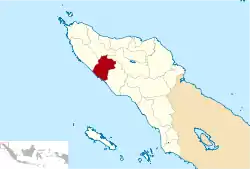 Location within Aceh | |
| Coordinates: 4°27′N 96°11′E / 4.450°N 96.183°E | |
| Country | |
| Region | Sumatra |
| Province | |
| Established | 1956 |
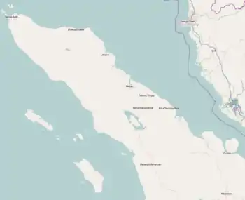
| Regency seat | Meulaboh |
| Government | |
| • Regent | Mahdi Efendi |
| • Vice Regent | Vacant |
| Area | |
| • Total | 2,782.87 km2 (1,074.47 sq mi) |
| Population (mid 2022 estimate)[1] | |
| • Total | 202,858 |
| • Density | 73/km2 (190/sq mi) |
| Time zone | UTC+7 (IWST) |
| Area code | (+62) 655 |
| Website | acehbaratkab.go.id |
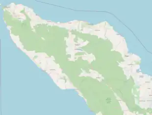

West Aceh Regency (Indonesian: Kabupaten Aceh Barat) is a regency in the Aceh special region of Indonesia. It is located on the island of Sumatra. The regency currently covers an area of 2,927.95 square kilometres and had a population of 173,558 at the 2010 Census[2] and 198,736 at the 2020 Census;[3] the official estimate as at mid 2022 was 202,858.[1] The town of Meulaboh remains the seat of the regency government (notwithstanding incorrect reports that on 8 July 2013 it was separated out as an independent city). The regency is a palm oil-producing area.[4] Some of the people of the regency are Minangkabau-descended Aneuk Jamee.[5]
The regency was among the hardest-hit areas during the 2004 Indian Ocean earthquake.
The regency is bordered by the regencies of Aceh Jaya to the west, Pidie to the north, Central Aceh to the northeast, and Nagan Raya to the southeast, and by the Indian Ocean to the southwest.
Administrative districts
The regency was divided administratively into twelve districts (kecamatan), listed below with their areas and populations at the 2010 Census[2] and the 2020 Census,[3] together with the official estimates as at mid 2022.[1] The table also includes the location of the district administrative centres, and the number of administrative villages (gampong) in each district, and its post code.
| Kode Wilayah | Name of District (kecamatan) | Area in km2 | Pop'n Census 2010 | Pop'n Census 2020 | Pop'n Estimate mid 2022 | Admin centre | No. of villages | Post code |
|---|---|---|---|---|---|---|---|---|
| 11.05.01 | Johan Pahlawan | 44.91 | 56,050 | 64,646 | 66,216 | Meulaboh | 21 | 23617 & 23618 |
| 11.05.05 | Samatiga | 140.69 | 13,322 | 15,656 | 16,006 | Suak Timah | 32 | 23650 |
| 11.05.06 | Bubon | 129.58 | 6,545 | 6,817 | 6,870 | Banda Layung | 17 | 23651 |
| 11.05.07 | Arongan Lambalek | 130.06 | 10,609 | 11,871 | 12,060 | Drien Rampak | 27 | 23652 |
| 11.05.04 | Woyla | 249.04 | 12,073 | 13,576 | 13,811 | Kuala Bhee | 43 | 23654 |
| 11.05.10 | Woyla Barat (West Woyla) | 123.00 | 6,858 | 7,837 | 7,981 | Pasi Mali | 24 | 23682 |
| 11.05.11 | Woyla Timur (East Woyla) | 132.60 | 4,138 | 5,144 | 5,277 | Tangkeh | 26 | 23683 |
| 11.05.02 | Kaway XVI | 510.18 | 18,753 | 21,216 | 21,590 | Keudee Aron | 44 | 23681 |
| 11.05.09 | Meureubo | 112.87 | 26,510 | 30,066 | 30,700 | Meureubo | 26 | 23615 |
| 11.05.08 | Pantai Ceuremen | 490.25 | 9,635 | 11,133 | 11,339 | Pante Ceureumen | 25 | 23680 |
| 11.05.12 | Panton Reu | 83.04 | 5,671 | 6,586 | 6,713 | Meutulang | 19 | 23684 |
| 11.05.03 | Sungai Mas | 781.73 | 3,394 | 4,188 | 4,295 | Kajeung | 18 | 23685 |
| Totals | 2,927.95 | 173,558 | 198,736 | 202,858 | Meulaboh | 322 |
See also
References
- 1 2 3 Badan Pusat Statistik, Jakarta, 2023, Kabupaten Aceh Barat Dalam Angka 2023 (Katalog-BPS 1102001.1105)
- 1 2 Biro Pusat Statistik, Jakarta, 2011.
- 1 2 Badan Pusat Statistik, Jakarta, 2021.
- ↑ Indonesia. Departemen Penerangan; Japenpa Foreign Languages Publishing Institute (1975). Indonesia handbook. Dept. of Information, Republic of Indonesia. Retrieved 20 December 2010.
- ↑ Davies, Matthew N. (2006). Indonesia's war over Aceh: last stand on Mecca's porch. Taylor & Francis. pp. 21–. ISBN 978-0-415-37239-8. Archived from the original on 15 September 2023. Retrieved 20 December 2010.
Regencies and cities of Aceh | ||
|---|---|---|
Capital: Banda Aceh | ||
| Regencies |  | |
| Cities | ||