Bohuslavice | |
|---|---|
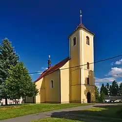 Church of Saint Bartholomew | |
 Flag  Coat of arms | |
 Bohuslavice Location in the Czech Republic | |
| Coordinates: 49°37′15″N 16°57′27″E / 49.62083°N 16.95750°E | |
| Country | |
| Region | Olomouc |
| District | Prostějov |
| First mentioned | 1288 |
| Area | |
| • Total | 4.87 km2 (1.88 sq mi) |
| Elevation | 409 m (1,342 ft) |
| Population (2023-01-01)[1] | |
| • Total | 439 |
| • Density | 90/km2 (230/sq mi) |
| Time zone | UTC+1 (CET) |
| • Summer (DST) | UTC+2 (CEST) |
| Postal code | 798 56 |
| Website | www |
Bohuslavice is a municipality and village in Prostějov District in the Olomouc Region of the Czech Republic. It has about 400 inhabitants.
Bohuslavice lies approximately 20 kilometres (12 mi) north-west of Prostějov, 22 km (14 mi) west of Olomouc, and 190 km (120 mi) east of Prague.
References
Wikimedia Commons has media related to Bohuslavice (Prostějov District).
This article is issued from Wikipedia. The text is licensed under Creative Commons - Attribution - Sharealike. Additional terms may apply for the media files.