Vranovice-Kelčice | |
|---|---|
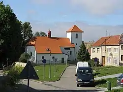 Church of Saint Cunigunde | |
 Flag  Coat of arms | |
 Vranovice-Kelčice Location in the Czech Republic | |
| Coordinates: 49°24′13″N 17°6′1″E / 49.40361°N 17.10028°E | |
| Country | |
| Region | Olomouc |
| District | Prostějov |
| First mentioned | 1258 |
| Area | |
| • Total | 7.87 km2 (3.04 sq mi) |
| Elevation | 233 m (764 ft) |
| Population (2023-01-01)[1] | |
| • Total | 604 |
| • Density | 77/km2 (200/sq mi) |
| Time zone | UTC+1 (CET) |
| • Summer (DST) | UTC+2 (CEST) |
| Postal code | 798 08 |
| Website | www |
Vranovice-Kelčice is a municipality in Prostějov District in the Olomouc Region of the Czech Republic. It has about 600 inhabitants.
Vranovice-Kelčice lies approximately 9 kilometres (6 mi) south of Prostějov, 25 km (16 mi) south-west of Olomouc, and 208 km (129 mi) east of Prague.
Administrative parts
The municipality is made up of villages of Vranovice and Kelčice.
History
The first written mention of Kelčice is from 1258. The first written mention of Vranovice is from 1337. The two formerly separate municipalities merged in 1964.[2]
References
- ↑ "Population of Municipalities – 1 January 2023". Czech Statistical Office. 2023-05-23.
- ↑ "Naše historie" (in Czech). Obec Vranovice-Kelčice. Retrieved 2022-02-08.
External links
Wikimedia Commons has media related to Vranovice-Kelčice.
This article is issued from Wikipedia. The text is licensed under Creative Commons - Attribution - Sharealike. Additional terms may apply for the media files.