Bourdons-sur-Rognon | |
|---|---|
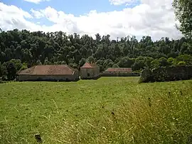 The Crête abbey in Bourdons-sur-Rognon | |
 Coat of arms | |
Location of Bourdons-sur-Rognon | |
 Bourdons-sur-Rognon  Bourdons-sur-Rognon | |
| Coordinates: 48°10′03″N 5°21′03″E / 48.1675°N 5.3508°E | |
| Country | France |
| Region | Grand Est |
| Department | Haute-Marne |
| Arrondissement | Chaumont |
| Canton | Bologne |
| Government | |
| • Mayor (2020–2026) | Gilles Berthet[1] |
| Area 1 | 39.45 km2 (15.23 sq mi) |
| Population | 294 |
| • Density | 7.5/km2 (19/sq mi) |
| Time zone | UTC+01:00 (CET) |
| • Summer (DST) | UTC+02:00 (CEST) |
| INSEE/Postal code | 52061 /52700 |
| Elevation | 310–360 m (1,020–1,180 ft) (avg. 338 m or 1,109 ft) |
| 1 French Land Register data, which excludes lakes, ponds, glaciers > 1 km2 (0.386 sq mi or 247 acres) and river estuaries. | |
Bourdons-sur-Rognon (French pronunciation: [buʁdɔ̃ syʁ ʁɔɲɔ̃]) is a commune in the Haute-Marne department in northeastern France.
The former La Crête Abbey was located here.
Population
| Year | Pop. | ±% p.a. |
|---|---|---|
| 1968 | 413 | — |
| 1975 | 365 | −1.75% |
| 1982 | 338 | −1.09% |
| 1990 | 306 | −1.24% |
| 1999 | 294 | −0.44% |
| 2009 | 281 | −0.45% |
| 2014 | 268 | −0.94% |
| 2020 | 294 | +1.56% |
| Source: INSEE[3] | ||
See also
References
- ↑ "Répertoire national des élus: les maires". data.gouv.fr, Plateforme ouverte des données publiques françaises (in French). 2 December 2020.
- ↑ "Populations légales 2021". The National Institute of Statistics and Economic Studies. 28 December 2023.
- ↑ Population en historique depuis 1968, INSEE
Wikimedia Commons has media related to Bourdons-sur-Rognon.
This article is issued from Wikipedia. The text is licensed under Creative Commons - Attribution - Sharealike. Additional terms may apply for the media files.