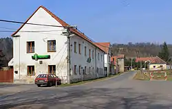
Děkov | |
|---|---|
 Restaurant by the main road | |
 Děkov Location in the Czech Republic | |
| Coordinates: 50°10′17″N 13°33′16″E / 50.17139°N 13.55444°E | |
| Country | |
| Region | Central Bohemian |
| District | Rakovník |
| First mentioned | 1325 |
| Area | |
| • Total | 9.05 km2 (3.49 sq mi) |
| Elevation | 372 m (1,220 ft) |
| Population (2023-01-01)[1] | |
| • Total | 237 |
| • Density | 26/km2 (68/sq mi) |
| Time zone | UTC+1 (CET) |
| • Summer (DST) | UTC+2 (CEST) |
| Postal code | 270 04 |
| Website | www |
Děkov is a municipality and village in Rakovník District in the Central Bohemian Region of the Czech Republic. It has about 200 inhabitants.
Administrative parts
Villages of Nová Ves and Vlkov are administrative parts of Děkov.
Geography
Děkov is located about 14 km (9 mi) northwest of Rakovník and 57 km (35 mi) west of Prague. It lies in the Rakovník Uplands. The highest point is the flat hill Novoveský vrch at 440 m (1,440 ft) above sea level.
History
The first written mention of Děkov is from 1325.[2]
Sights
The main landmark of Děkov is the Church of Saint John the Baptist. It was first mentioned in 1361. In 1664, it was replaced by the current early Baroque building. The church was rebuilt in 1729 and extended in 1868.[3]
References
- ↑ "Population of Municipalities – 1 January 2023". Czech Statistical Office. 2023-05-23.
- ↑ "Obec Děkov" (in Czech). Obec Hořesedly. Retrieved 2023-02-16.
- ↑ "Kostel sv. Jana Křtitele" (in Czech). National Heritage Institute. Retrieved 2023-02-16.
External links
Wikimedia Commons has media related to Děkov.
This article is issued from Wikipedia. The text is licensed under Creative Commons - Attribution - Sharealike. Additional terms may apply for the media files.