Slabce | |
|---|---|
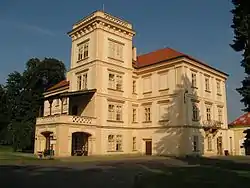
 Castle in Slabce | |
 Flag  Coat of arms | |
 Slabce Location in the Czech Republic | |
| Coordinates: 50°0′0″N 13°42′53″E / 50.00000°N 13.71472°E | |
| Country | |
| Region | Central Bohemian |
| District | Rakovník |
| First mentioned | 1352 |
| Area | |
| • Total | 27.64 km2 (10.67 sq mi) |
| Elevation | 419 m (1,375 ft) |
| Population (2023-01-01)[1] | |
| • Total | 728 |
| • Density | 26/km2 (68/sq mi) |
| Time zone | UTC+1 (CET) |
| • Summer (DST) | UTC+2 (CEST) |
| Postal code | 270 41 |
| Website | www |
Slabce (Czech pronunciation: [ˈslaptsɛ]) is a market town in Rakovník District in the Central Bohemian Region of the Czech Republic. It has about 700 inhabitants.
Administrative parts
Villages of Kostelík, Malé Slabce, Modřejovice, Nová Ves, Rousínov, Skupá and Svinařov are administrative parts of Slabce.
Geography
Slabce is located about 5 km (3 mi) south of Rakovník and 43 km (27 mi) west of Prague. It lies in the Plasy Uplands. The highest point is the hill Hůrka at 492 m (1,614 ft) above sea level. The Berounka River flows along the southern municipal border. The almost entire municipal territory lies in the Křivoklátsko Protected Landscape Area.
Notable people
- Karel Burian (1870–1924), operatic tenor
References
External links
Wikimedia Commons has media related to Slabce.
This article is issued from Wikipedia. The text is licensed under Creative Commons - Attribution - Sharealike. Additional terms may apply for the media files.