Městečko | |
|---|---|
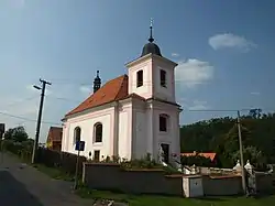
 Church of Saint James the Great | |
 Městečko Location in the Czech Republic | |
| Coordinates: 50°3′3″N 13°51′49″E / 50.05083°N 13.86361°E | |
| Country | |
| Region | Central Bohemian |
| District | Rakovník |
| First mentioned | 1352 |
| Area | |
| • Total | 14.41 km2 (5.56 sq mi) |
| Elevation | 265 m (869 ft) |
| Population (2023-01-01)[1] | |
| • Total | 452 |
| • Density | 31/km2 (81/sq mi) |
| Time zone | UTC+1 (CET) |
| • Summer (DST) | UTC+2 (CEST) |
| Postal code | 270 23 |
| Website | www |
Městečko is a municipality and village in Rakovník District in the Central Bohemian Region of the Czech Republic. It has about 500 inhabitants.
Geography
Městečko is located about 10 km (6 mi) southeast of Rakovník and 33 km (21 mi) west of Prague. It lies on the border between the Křivoklát Highlands and Plasy Uplands. The highest point is the hill Mečná at 433 m (1,421 ft) above sea level. The built-up area is situated in the valley of the Rakovnický Stream and its tributary, the Ryšava Stream. The northern municipal border is formed by the Klíčava River and Klíčava Reservoir. The entire municipality lies in the Křivoklátsko Protected Landscape Area.
History
The first written mention of Městečko is from 1352, under the name Městec. The name Městečko first appeared in 1558. During the Hussite Wars, the settlement was completely destroyed and had to be rebuilt. The same situation was repeated during the Thirty Years' War, after which no inhabitants remained in the village, and it was restored only after its end in 1648.[2]
Sights
The landmark of Městečko is the Church of Saint James the Great. The originally Gothic church was baroque rebuilt into its current form in 1733.[2]
Notable people
- Josef Trousil (born 1935), athlete
References
- ↑ "Population of Municipalities – 1 January 2023". Czech Statistical Office. 2023-05-23.
- 1 2 "Historie obce Městečko" (in Czech). Obec Městečko. Retrieved 2023-02-16.