Dobšín | |
|---|---|
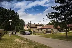 A street in Dobšín | |
 Flag  Coat of arms | |
 Dobšín Location in the Czech Republic | |
| Coordinates: 50°29′0″N 15°7′0″E / 50.48333°N 15.11667°E | |
| Country | |
| Region | Central Bohemian |
| District | Mladá Boleslav |
| First mentioned | 1556 |
| Area | |
| • Total | 3.54 km2 (1.37 sq mi) |
| Elevation | 315 m (1,033 ft) |
| Population (2023-01-01)[1] | |
| • Total | 286 |
| • Density | 81/km2 (210/sq mi) |
| Time zone | UTC+1 (CET) |
| • Summer (DST) | UTC+2 (CEST) |
| Postal code | 294 04 |
| Website | www |
Dobšín is a municipality and village in Mladá Boleslav District in the Central Bohemian Region of the Czech Republic. It has about 300 inhabitants.
Administrative parts
The village of Kamenice is an administrative part of Dobšín.
References
Wikimedia Commons has media related to Dobšín.
This article is issued from Wikipedia. The text is licensed under Creative Commons - Attribution - Sharealike. Additional terms may apply for the media files.