Katusice | |
|---|---|
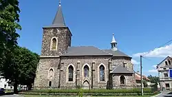
 Church of the Assumption of the Virgin Mary | |
 Flag  Coat of arms | |
 Katusice Location in the Czech Republic | |
| Coordinates: 50°26′43″N 14°46′39″E / 50.44528°N 14.77750°E | |
| Country | |
| Region | Central Bohemian |
| District | Mladá Boleslav |
| First mentioned | 1352 |
| Area | |
| • Total | 16.13 km2 (6.23 sq mi) |
| Elevation | 308 m (1,010 ft) |
| Population (2023-01-01)[1] | |
| • Total | 840 |
| • Density | 52/km2 (130/sq mi) |
| Time zone | UTC+1 (CET) |
| • Summer (DST) | UTC+2 (CEST) |
| Postal codes | 294 25, 294 26 |
| Website | obec-katusice |
Katusice is a municipality and village in Mladá Boleslav District in the Central Bohemian Region of the Czech Republic. It has about 800 inhabitants.
Administrative parts
Villages of Doubravice, Spikaly, Trnová and Valovice are administrative parts of Katusice. Doubravice and Trnová form an exclave of the municipal territory.
Geography
Katusice is located about 10 kilometres (6 mi) west of Mladá Boleslav and 41 km (25 mi) northeast of Prague. It lies in the Jizera Table. The highest point is the hill Bezvel at 340 m (1,120 ft) above sea level.
History
The first written mention of Katusice is from 1352, when the local church was documented.[2]
Transport
Katusice is located on a railway line from Mělník to Mladá Boleslav and Mladějov.
Sights
The landmark of Katusice is the Church of the Assumption of the Virgin Mary. It is a neo-Gothic parish church with a Gothic-Renaissance core. It was built in 1853–1857.[3]
References
- ↑ "Population of Municipalities – 1 January 2023". Czech Statistical Office. 2023-05-23.
- ↑ "Památky v obci" (in Czech). Obec Katusice. Retrieved 2023-03-14.
- ↑ "Kostel Nanebevzetí Panny Marie" (in Czech). National Heritage Institute. Retrieved 2023-03-14.