| Eynali | |
|---|---|
 A view from station 1. | |
| Highest point | |
| Elevation | 1,800 m (5,900 ft)(Eynali peak) 2,378 m (7,802 ft) (Dand peak) |
| Coordinates | 38°06′20″N 46°19′20″E / 38.10556°N 46.32222°E |
| Geography | |
| Location | Tabriz, Iran |
| Geology | |
| Last eruption | Unknown |
| Climbing | |
| Easiest route | The pavement trail, 2 miles (3.3 km) to Eynali peak. |
Eynali (Persian: عینالی), or On ibn Ali (عون بن علی), is a mountain range in north of Tabriz, Iran. The range has a couple of peaks including Eynali (1800 m), Halileh (1850 m), Pakeh-chin (1945 m), Bahlul (1985 m) and the highest one Dand (2378 m).[1] There is a tomb at top of the mountain which is believed to be the grave of two clerics which the mountain's name is related to them. There is a belief among people that originally the building was a Zoroasterian temple or a Church that the shrine name to is a cover to saving the structure from destruction during Muslims invasion.
Photo gallery
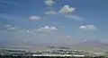 A view from the southern hills of Tabriz with Eynali is visible in North of Tabriz.
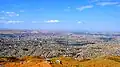 A view of Tabriz from Eynali foothills.
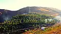 Artificial forest of Eynali.
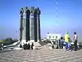 A memorial in Eynali, in memory of those who lost their life during the war.
See also
Wikimedia Commons has media related to Eynali.
References
- ↑ East Azerbaijan Mountaineering Confederation Archived September 25, 2009, at the Wayback Machine

This article is issued from Wikipedia. The text is licensed under Creative Commons - Attribution - Sharealike. Additional terms may apply for the media files.