Freedom Township | |
|---|---|
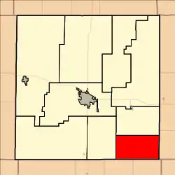 Location in Ellis County | |
| Coordinates: 38°44′00″N 099°07′30″W / 38.73333°N 99.12500°W | |
| Country | United States |
| State | Kansas |
| County | Ellis |
| Area | |
| • Total | 45.1 sq mi (116.82 km2) |
| • Land | 45.1 sq mi (116.82 km2) |
| • Water | 0 sq mi (0 km2) 0% |
| Elevation | 1,929 ft (588 m) |
| Population (2000) | |
| • Total | 118 |
| • Density | 2.6/sq mi (1.0/km2) |
| GNIS feature ID | 0475299 |
Freedom Township is a township in Ellis County, Kansas, USA. As of the 2010 census, its population was 118.
Geography
Freedom Township covers an area of 45.1 square miles (117 km2) and contains no incorporated settlements. According to the USGS, it contains one cemetery, Holy Cross.
The streams of Duck Creek and Eagle Creek run through this township.
References
External links
Municipalities and communities of Ellis County, Kansas, United States | ||
|---|---|---|
| Cities | 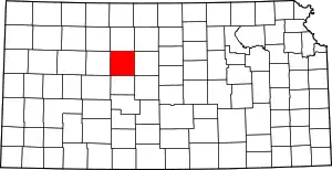 Map of Kansas highlighting Ellis County | |
| Unincorporated communities | ||
| Ghost towns | ||
| Townships | ||
| Footnotes | †This community is designated a Census-Designated Place (CDP) by the United States Census Bureau. | |
This article is issued from Wikipedia. The text is licensed under Creative Commons - Attribution - Sharealike. Additional terms may apply for the media files.