Hog Back, Kansas | |
|---|---|
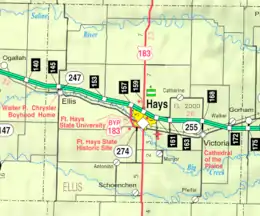 KDOT map of Ellis County (legend) | |
 Hog Back  Hog Back | |
| Coordinates: 38°55′13″N 99°28′51″W / 38.92028°N 99.48083°W[1] | |
| Country | United States |
| State | Kansas |
| County | Ellis |
| Elevation | 2,077 ft (633 m) |
| Population | |
| • Total | 0 |
| Time zone | UTC-6 (CST) |
| • Summer (DST) | UTC-5 (CDT) |
| Area code | 785 |
| FIPS code | 20-32500 [1] |
| GNIS ID | 484722 [1] |
Hog Back is a ghost town in Pleasant Hill Township, Ellis County, Kansas, United States.[1]
History
Hog Back was a railroad siding and granary 3 miles (4.8 km) east of Ellis.[2][3]
References
Further reading
External links
Municipalities and communities of Ellis County, Kansas, United States | ||
|---|---|---|
| Cities | 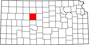 Map of Kansas highlighting Ellis County | |
| Unincorporated communities | ||
| Ghost towns | ||
| Townships | ||
| Footnotes | †This community is designated a Census-Designated Place (CDP) by the United States Census Bureau. | |
This article is issued from Wikipedia. The text is licensed under Creative Commons - Attribution - Sharealike. Additional terms may apply for the media files.