Mendota, Kansas | |
|---|---|
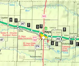 KDOT map of Ellis County (legend) | |
 Mendota  Mendota | |
| Coordinates: 39°06′35″N 99°33′21″W / 39.10972°N 99.55583°W | |
| Country | United States |
| State | Kansas |
| County | Ellis |
| Elevation | 2,024 ft (617 m) |
| Population | |
| • Total | 0 |
| Time zone | UTC-6 (CST) |
| • Summer (DST) | UTC-5 (CDT) |
| Area code | 785 |
| GNIS ID | 485334[1] |
Mendota is a ghost town in Hamilton Township, Ellis County, Kansas, United States.
History
Initially named Halton, it was issued a post office in 1878. The name was changed to Mendota in 1882. The post office was discontinued in 1909.[2]
References
- ↑ "US Board on Geographic Names". United States Geological Survey. 1984-07-01. Retrieved 2017-12-30.
- ↑ "Kansas Post Offices, 1828-1961". Kansas Historical Society. Retrieved 2017-12-30.
Further reading
External links
Municipalities and communities of Ellis County, Kansas, United States | ||
|---|---|---|
| Cities | 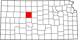 Map of Kansas highlighting Ellis County | |
| Unincorporated communities | ||
| Ghost towns | ||
| Townships | ||
| Footnotes | †This community is designated a Census-Designated Place (CDP) by the United States Census Bureau. | |
This article is issued from Wikipedia. The text is licensed under Creative Commons - Attribution - Sharealike. Additional terms may apply for the media files.