Johnson County | |
|---|---|
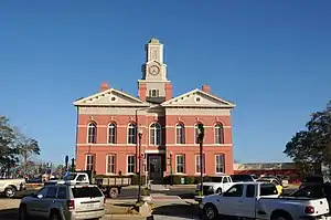 Johnson County Courthouse in Wrightsville | |
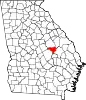 Location within the U.S. state of Georgia | |
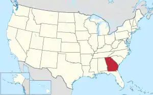 Georgia's location within the U.S. | |
| Coordinates: 32°42′N 82°40′W / 32.7°N 82.66°W | |
| Country | |
| State | |
| Founded | December 11, 1858 |
| Named for | Herschel Vespasian Johnson |
| Seat | Wrightsville |
| Largest city | Wrightsville |
| Area | |
| • Total | 307 sq mi (800 km2) |
| • Land | 303 sq mi (780 km2) |
| • Water | 3.6 sq mi (9 km2) 1.2% |
| Population (2020) | |
| • Total | 9,189 |
| • Density | 30/sq mi (10/km2) |
| Time zone | UTC−5 (Eastern) |
| • Summer (DST) | UTC−4 (EDT) |
| Congressional district | 10th |
| Website | www |
Johnson County is a county located in the U.S. state of Georgia. As of the 2020 census, the population was 9,189.[1] The county seat is Wrightsville.[2] Johnson County is part of the Dublin, Georgia, micropolitan statistical area.
History
Johnson county was created by the Georgia legislature December 11, 1858, from parts of Emanuel, Laurens, and Washington counties. Johnson County was named for Georgia governor, senator, and U.S. vice-presidential candidate Herschel Vespasian Johnson.[3]
In 1919, a deputy driving Jim Waters, a black prisoner accused of rape, out of the county was stopped by a group of 150 men at a bridge over the Ohoopee River. The men tied Waters to a tree and shot him numerous times. The case was closed without any investigation.[4]
Geography
According to the U.S. Census Bureau, the county has a total area of 307 square miles (800 km2), of which 303 square miles (780 km2) is land and 3.6 square miles (9.3 km2) (1.2%) is water.[5]
The vast majority of Johnson County is located in the Ohoopee River sub-basin of the Altamaha River basin. Tiny portions of the northeastern borders of the county are located in the Upper Ogeechee River sub-basin of the Ogeechee River basin, while the western corner of Johnson County is located in the Lower Oconee River sub-basin of the Altamaha River basin.[6]
Major highways
Adjacent counties
- Washington County - north
- Jefferson County - northeast
- Emanuel County - east
- Treutlen County - south
- Laurens County - southwest
- Wilkinson County - west
Communities
- Adrian
- Kite
- Meeks
- Wrightsville (county seat)
Demographics
| Census | Pop. | Note | %± |
|---|---|---|---|
| 1860 | 2,919 | — | |
| 1870 | 2,964 | 1.5% | |
| 1880 | 4,800 | 61.9% | |
| 1890 | 6,129 | 27.7% | |
| 1900 | 11,409 | 86.1% | |
| 1910 | 12,897 | 13.0% | |
| 1920 | 13,546 | 5.0% | |
| 1930 | 12,681 | −6.4% | |
| 1940 | 12,953 | 2.1% | |
| 1950 | 9,893 | −23.6% | |
| 1960 | 8,048 | −18.6% | |
| 1970 | 7,727 | −4.0% | |
| 1980 | 8,660 | 12.1% | |
| 1990 | 8,329 | −3.8% | |
| 2000 | 8,560 | 2.8% | |
| 2010 | 9,980 | 16.6% | |
| 2020 | 9,189 | −7.9% | |
| U.S. Decennial Census[7] 1790-1880[8]1890-1910[9] 1920-1930[10] 1930-1940[11] 1940-1950[12] 1960-1980[13] 1980-2000[14] 2010[15] | |||
| Race | Num. | Perc. |
|---|---|---|
| White (non-Hispanic) | 5,800 | 63.12% |
| Black or African American (non-Hispanic) | 3,017 | 32.83% |
| Native American | 23 | 0.25% |
| Asian | 28 | 0.3% |
| Pacific Islander | 15 | 0.16% |
| Other/Mixed | 189 | 2.06% |
| Hispanic or Latino | 117 | 1.27% |
As of the 2020 United States census, there were 9,189 people, 3,393 households, and 2,208 families residing in the county.
Government
The county is governed by a five-member board of commissioners. A county manager handles the daily operation of the county.
The county is part of the Dublin Judicial Circuit along with Twiggs County, Treutlen County, and Laurens County.
| Year | Republican | Democratic | Third party | |||
|---|---|---|---|---|---|---|
| No. | % | No. | % | No. | % | |
| 2020 | 2,850 | 69.51% | 1,222 | 29.80% | 28 | 0.68% |
| 2016 | 2,519 | 68.34% | 1,136 | 30.82% | 31 | 0.84% |
| 2012 | 2,440 | 64.62% | 1,305 | 34.56% | 31 | 0.82% |
| 2008 | 2,426 | 66.47% | 1,198 | 32.82% | 26 | 0.71% |
| 2004 | 2,279 | 64.11% | 1,263 | 35.53% | 13 | 0.37% |
| 2000 | 1,797 | 62.33% | 1,065 | 36.94% | 21 | 0.73% |
| 1996 | 815 | 36.14% | 1,194 | 52.95% | 246 | 10.91% |
| 1992 | 1,314 | 39.88% | 1,473 | 44.70% | 508 | 15.42% |
| 1988 | 1,567 | 62.83% | 927 | 37.17% | 0 | 0.00% |
| 1984 | 1,733 | 59.11% | 1,199 | 40.89% | 0 | 0.00% |
| 1980 | 1,123 | 37.07% | 1,854 | 61.21% | 52 | 1.72% |
| 1976 | 698 | 24.00% | 2,210 | 76.00% | 0 | 0.00% |
| 1972 | 2,201 | 84.07% | 417 | 15.93% | 0 | 0.00% |
| 1968 | 381 | 13.28% | 446 | 15.55% | 2,041 | 71.16% |
| 1964 | 1,940 | 73.99% | 682 | 26.01% | 0 | 0.00% |
| 1960 | 488 | 27.32% | 1,298 | 72.68% | 0 | 0.00% |
| 1956 | 179 | 10.02% | 1,607 | 89.98% | 0 | 0.00% |
| 1952 | 344 | 15.99% | 1,808 | 84.01% | 0 | 0.00% |
| 1948 | 67 | 5.33% | 685 | 54.54% | 504 | 40.13% |
| 1944 | 304 | 23.71% | 978 | 76.29% | 0 | 0.00% |
| 1940 | 306 | 11.32% | 2,386 | 88.24% | 12 | 0.44% |
| 1936 | 334 | 15.15% | 1,861 | 84.40% | 10 | 0.45% |
| 1932 | 18 | 1.34% | 1,314 | 98.06% | 8 | 0.60% |
| 1928 | 284 | 31.00% | 632 | 69.00% | 0 | 0.00% |
| 1924 | 194 | 14.18% | 1,058 | 77.34% | 116 | 8.48% |
| 1920 | 74 | 19.47% | 306 | 80.53% | 0 | 0.00% |
| 1916 | 150 | 16.95% | 715 | 80.79% | 20 | 2.26% |
| 1912 | 92 | 23.00% | 285 | 71.25% | 23 | 5.75% |
Education
In 1970, Johnson County schools integrated peacefully due to careful planning by the county's board of education and firm management by superintendent Buren Claxton.
The county's public schools are located in Wrightsville. The school mascot is the Trojan, and the school colors are blue and white. The school fight song is the theme from the movie Hang 'Em High.
Sports
Herschel Walker, a Johnson County native, played on the county's only state championship football team in 1979. Walker went on to play for the University of Georgia and won the Heisman Trophy. In 2004 Johnson County High School named its football field for Walker.
See also
References
- ↑ "Census - Geography Profile: Johnson County, Georgia". United States Census Bureau. Retrieved December 27, 2022.
- ↑ "Find a County". National Association of Counties. Archived from the original on May 9, 2015. Retrieved June 7, 2011.
- ↑ Gannett, Henry (1905). The Origin of Certain Place Names in the United States. Govt. Print. Off. pp. 169.
- ↑ McWhirter, Cameron (2011). Red Summer: The Summer of 1919 and the Awakening of Black America. Henry Holt and Company. p. 52. ISBN 978-1-4299-7293-2.
- ↑ "US Gazetteer files: 2010, 2000, and 1990". United States Census Bureau. February 12, 2011. Retrieved April 23, 2011.
- ↑ "Georgia Soil and Water Conservation Commission Interactive Mapping Experience". Georgia Soil and Water Conservation Commission. Archived from the original on October 3, 2018. Retrieved November 20, 2015.
- ↑ "Decennial Census of Population and Housing by Decades". US Census Bureau.
- ↑ "1880 Census Population by Counties 1790-1800" (PDF). US Census Bureau. 1880.
- ↑ "1910 Census of Population - Georgia" (PDF). US Census Bureau. 1910.
- ↑ "1930 Census of Population - Georgia" (PDF). US Census Bureau. 1930.
- ↑ "1940 Census of Population - Georgia" (PDF). US Census Bureau. 1940.
- ↑ "1950 Census of Population - Georgia -" (PDF). US Census Bureau. 1950.
- ↑ "1980 Census of Population - Number of Inhabitants - Georgia" (PDF). US Census Bureau. 1980.
- ↑ "2000 Census of Population - Population and Housing Unit Counts - Georgia" (PDF). US Census Bureau. 2000.
- ↑ "State & County QuickFacts". United States Census Bureau. Archived from the original on June 7, 2011. Retrieved June 23, 2014.
- ↑ "Explore Census Data". data.census.gov. Retrieved December 18, 2021.
- ↑ Leip, David. "Dave Leip's Atlas of U.S. Presidential Elections". uselectionatlas.org. Retrieved March 20, 2018.
External links
Places adjacent to Johnson County, Georgia | ||||||||||||||||
|---|---|---|---|---|---|---|---|---|---|---|---|---|---|---|---|---|
| ||||||||||||||||
Municipalities and communities of Johnson County, Georgia, United States | ||
|---|---|---|
| Cities | Map of Georgia highlighting Johnson County | |
| Unincorporated communities | ||
| Footnotes | ‡This populated place also has portions in an adjacent county or counties | |