Karaj County
Persian: شهرستان کرج | |
|---|---|
County | |
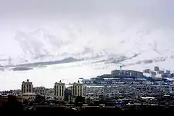 Karaj in winter | |
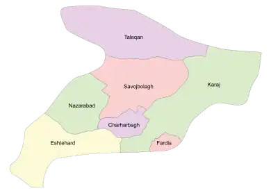 Location of Karaj County in Alborz province (right, green) | |
 Location of Alborz province in Iran | |
| Coordinates: 35°58′N 51°05′E / 35.967°N 51.083°E[1] | |
| Country | |
| Province | Alborz |
| Capital | Karaj |
| Districts | Central, Asara |
| Population (2016)[2] | |
| • Total | 1,973,470 |
| Time zone | UTC+3:30 (IRST) |
| Karaj County can be found at GEOnet Names Server, at this link, by opening the Advanced Search box, entering "9206117" in the "Unique Feature Id" form, and clicking on "Search Database". | |
Karaj County (Persian: شهرستان کرج) is in Alborz province, Iran. The capital of the county is the city of Karaj.[3]
At the 2006 census, its population (as a part of Tehran province) was 1,709,481 in 472,365 households.[4]
In June 2012, Eshtehard District was separated from the county in the establishment of Eshtehard County, which was divided into two districts of two rural districts each, with the city of Eshtehard as its capital and only city at the time.[5]
In July 2013, the city of Meshkin Dasht was separated from the county to join the newly established Fardis County.[6]
At the 2016 census, the county's population was 1,973,470 in 623,801 households,[2] by which time it had become a part of recently established Alborz province.[3]
Administrative divisions
The population history and structural changes of Karaj County's administrative divisions over two censuses are shown in the following table. The latest census shows two districts, six rural districts, and six cities.[2]
| Administrative Divisions | 2006[4] | 2016[2] | |
|---|---|---|---|
| Central District | 1,667,024 | 1,956,267 | |
| Garmdarreh RD | 544 | 221 | |
| Kamalabad RD | 3,836 | 4,892 | |
| Mohammadabad RD | 22,099 | 11,939 | |
| Garmdarreh (city) | 12,738 | 22,726 | |
| Kamal Shahr (city) | 80,435 | 141,669 | |
| Karaj (city) | 1,377,450 | 1,592,492 | |
| Mahdasht (city) | 43,100 | 62,910 | |
| Meshkin Dasht (city)1 | 43,696 | ||
| Mohammadshahr (city) | 83,126 | 119,418 | |
| Asara District | 18,856 | 17,150 | |
| Adaran RD | 8,995 | 7,679 | |
| Asara RD | 3,780 | 3,063 | |
| Nesa RD | 6,081 | 5,069 | |
| Asara (city) | 1,339 | ||
| Eshtehard District2 | 23,601 | ||
| Palangabad RD | 6,613 | ||
| Eshtehard (city) | 16,988 | ||
| Total | 1,709,481 | 1,973,470 | |
| RD: Rural District 1Became a part of Fardis County[6] 2Became a part of Eshtehard County[5] | |||
Gallery
 Karaj Valley
References
- ↑ OpenStreetMap contributors (25 March 2023). "Karaj County" (Map). OpenStreetMap. Retrieved 25 March 2023.
- 1 2 3 4 "Census of the Islamic Republic of Iran, 1395 (2016)". AMAR (in Persian). The Statistical Center of Iran. p. 30. Archived from the original (Excel) on 28 January 2020. Retrieved 19 December 2022.
- 1 2 Larijani, Ali (16 April 1389). "Alborz province establishment law". Lamtakam (in Persian). Guardian Council. Archived from the original on 16 December 2023. Retrieved 16 December 2023.
- 1 2 "Census of the Islamic Republic of Iran, 1385 (2006)". AMAR (in Persian). The Statistical Center of Iran. p. 23. Archived from the original (Excel) on 20 September 2011. Retrieved 25 September 2022.
- 1 2 Rahimi, Mohammadreza (10 June 2012). "Eshtehard county was added to the map of country divisions". DOLAT (in Persian). Ministry of Interior, Political and Defense Commission. Archived from the original on 23 September 2015. Retrieved 11 November 2023.
- 1 2 Rahimi, Mohammad Reza (7 July 2013). "With the approval of the government board: The counties of Fardis, Badreh and Balaveh were added to the map of country divisions". Mehr News (in Persian). Ministry of Interior, Board of Ministers. Archived from the original on 24 March 2023. Retrieved 11 November 2023.
| Capital city | 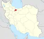 | ||||||||||||
|---|---|---|---|---|---|---|---|---|---|---|---|---|---|
| Counties and cities |
| ||||||||||||
| Sights |
| ||||||||||||
| Populated places | |||||||||||||
| Capital | |||||||||||||||||||||||||
|---|---|---|---|---|---|---|---|---|---|---|---|---|---|---|---|---|---|---|---|---|---|---|---|---|---|
| Districts |
| ||||||||||||||||||||||||