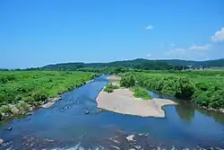
| Koyoshi River 子吉川 | |
|---|---|
 Koyoshi River in 2021 | |
| Location | |
| Country | Japan |
| State | Honshu |
| Region | Akita |
| Physical characteristics | |
| Source | Mount Chōkai[1][2] |
| • elevation | 2,236[3] m (7,336 ft) |
| Mouth | Sea of Japan |
• coordinates | 39°23′26″N 140°00′51″E / 39.3906°N 140.0141°E |
| Length | 61[1][2] km (38 mi) |
| Basin size | 1,190[1][2] km2 (460 sq mi) |
Koyoshi River (Japanese: 子吉川, Hepburn: koyoshigawa) is a river in Akita Prefecture, Japan. It originates from Mount Chōkai, where the border of Akita Prefecture and Yamagata Prefecture is located, and flows through Yurihonjō and finally into Sea of Japan. The headstream of the river is called Chōkai River (鳥海川, chōkaigawa).[1][2] It has the third largest drainage area of the class A rivers that flow through Akita Prefecture, after Omono River and Yoneshiro River.[4]
References
- 1 2 3 4 "日本の川 - 東北 - 子吉川 - 国土交通省水管理・国土保全局" (in Japanese). Ministry of Land, Infrastructure, Transport and Tourism, Japan. Retrieved December 28, 2017.
- 1 2 3 4 "子吉川(こよしがわ)とは - コトバンク" (in Japanese). kotobank. Retrieved December 28, 2017.
- ↑ "気象庁 鳥海山" (in Japanese). Japan Meteorological Agency. Retrieved December 28, 2017.
- ↑ "一級河川水系別延長等" (in Japanese). Ministry of Land, Infrastructure, Transport and Tourism, Japan. Retrieved December 28, 2017.
Wikimedia Commons has media related to Koyoshi River.
This article is issued from Wikipedia. The text is licensed under Creative Commons - Attribution - Sharealike. Additional terms may apply for the media files.