Kunčice pod Ondřejníkem | |
|---|---|
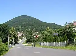 Kunčice pod Ondřejníkem under the Skalka hill | |
 Flag  Coat of arms | |
 Kunčice pod Ondřejníkem Location in the Czech Republic | |
| Coordinates: 49°33′2″N 18°15′40″E / 49.55056°N 18.26111°E | |
| Country | |
| Region | Moravian-Silesian |
| District | Frýdek-Místek |
| First mentioned | 1581 |
| Area | |
| • Total | 20.20 km2 (7.80 sq mi) |
| Elevation | 395 m (1,296 ft) |
| Population (2023-01-01)[1] | |
| • Total | 2,409 |
| • Density | 120/km2 (310/sq mi) |
| Time zone | UTC+1 (CET) |
| • Summer (DST) | UTC+2 (CEST) |
| Postal code | 739 13 |
| Website | www |
Kunčice pod Ondřejníkem is a municipality and village in Frýdek-Místek District in the Moravian-Silesian Region of the Czech Republic. It has about 2,400 inhabitants.
Geography
Kunčice pod Ondřejníkem lies mostly in the Moravian-Silesian Foothills, the southern part extends into the Moravian-Silesian Beskids. The highest point of the municipality is the Skalka hill at 964 metres (3,163 ft) above sea level.
Sights
The Church of Saints Procopius and Barbara is a wooden church from the end of the 17th century. It was relocated here from the Subcarpathian Rus in 1931.[2]
Gallery
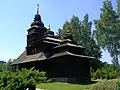 Church of Saints Procopius and Barbara
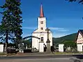 Church of Saint Mary Magdalene
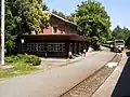 Train station
References
- ↑ "Population of Municipalities – 1 January 2023". Czech Statistical Office. 2023-05-23.
- ↑ "Kostel sv. Prokopa a sv. Barbory v Kunčicích pod Ondřejníkem" (in Czech). CzechTourism. Retrieved 2022-02-20.
External links
Wikimedia Commons has media related to Kunčice pod Ondřejníkem.
This article is issued from Wikipedia. The text is licensed under Creative Commons - Attribution - Sharealike. Additional terms may apply for the media files.