Lachaussée | |
|---|---|
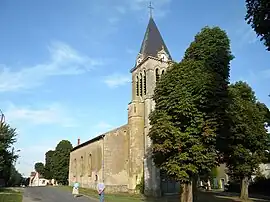 The church in Lachaussée | |
 Coat of arms | |
Location of Lachaussée | |
 Lachaussée  Lachaussée | |
| Coordinates: 49°02′16″N 5°49′10″E / 49.0378°N 5.8194°E | |
| Country | France |
| Region | Grand Est |
| Department | Meuse |
| Arrondissement | Commercy |
| Canton | Saint-Mihiel |
| Intercommunality | Côtes de Meuse - Woëvre |
| Government | |
| • Mayor (2020–2026) | Didier Kopocz[1] |
| Area 1 | 27.19 km2 (10.50 sq mi) |
| Population | 279 |
| • Density | 10/km2 (27/sq mi) |
| Time zone | UTC+01:00 (CET) |
| • Summer (DST) | UTC+02:00 (CEST) |
| INSEE/Postal code | 55267 /55210 |
| Elevation | 203–238 m (666–781 ft) (avg. 218 m or 715 ft) |
| 1 French Land Register data, which excludes lakes, ponds, glaciers > 1 km2 (0.386 sq mi or 247 acres) and river estuaries. | |
Lachaussée (French pronunciation: [laʃose]) is a commune in the Meuse department in Grand Est in north-eastern France.
Geography
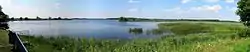
L'étang de Lachaussée
The village of Lachaussée lies on the south-eastern rim of a huge pond named Étang de Lachaussée, which was created during the middle ages from a marsh area and then devoted to pisciculture.
See also
References
- ↑ "Répertoire national des élus: les maires" (in French). data.gouv.fr, Plateforme ouverte des données publiques françaises. 13 September 2022.
- ↑ "Populations légales 2021". The National Institute of Statistics and Economic Studies. 28 December 2023.
Wikimedia Commons has media related to Lachaussée.
This article is issued from Wikipedia. The text is licensed under Creative Commons - Attribution - Sharealike. Additional terms may apply for the media files.