Lubenec | |
|---|---|
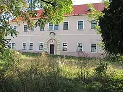 Former château and porcelain factory | |
 Flag  Coat of arms | |
 Lubenec Location in the Czech Republic | |
| Coordinates: 50°7′56″N 13°18′48″E / 50.13222°N 13.31333°E | |
| Country | |
| Region | Ústí nad Labem |
| District | Louny |
| First mentioned | 1115 |
| Area | |
| • Total | 36.65 km2 (14.15 sq mi) |
| Elevation | 373 m (1,224 ft) |
| Population (2023-01-01)[1] | |
| • Total | 1,334 |
| • Density | 36/km2 (94/sq mi) |
| Time zone | UTC+1 (CET) |
| • Summer (DST) | UTC+2 (CEST) |
| Postal codes | 439 83, 441 01 |
| Website | www |
Lubenec (German: Lubenz) is a municipality and village in Louny District in the Ústí nad Labem Region of the Czech Republic. It has about 1,300 inhabitants.
Lubenec lies approximately 43 kilometres (27 mi) south-west of Louny, 79 km (49 mi) south-west of Ústí nad Labem, and 80 km (50 mi) west of Prague.
Administrative parts
Villages of Dolní Záhoří, Drahonice, Horní Záhoří, Ležky, Libkovice, Libyně, Přibenice, Řepany and Vítkovice are administrative parts of Lubenec.
References
Wikimedia Commons has media related to Lubenec.
This article is issued from Wikipedia. The text is licensed under Creative Commons - Attribution - Sharealike. Additional terms may apply for the media files.