Slavětín | |
|---|---|
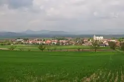 Panorama of Slavětín with the Central Bohemian Uplands in the background | |
 Coat of arms | |
 Slavětín Location in the Czech Republic | |
| Coordinates: 50°21′3″N 13°54′28″E / 50.35083°N 13.90778°E | |
| Country | |
| Region | Ústí nad Labem |
| District | Louny |
| First mentioned | 1269 |
| Area | |
| • Total | 8.37 km2 (3.23 sq mi) |
| Elevation | 230 m (750 ft) |
| Population (2023-01-01)[1] | |
| • Total | 638 |
| • Density | 76/km2 (200/sq mi) |
| Time zone | UTC+1 (CET) |
| • Summer (DST) | UTC+2 (CEST) |
| Postal codes | 439 09, 440 01 |
| Website | www |
Slavětín is a market town in Louny District in the Ústí nad Labem Region of the Czech Republic. It has about 600 inhabitants.
Slavětín lies approximately 8 kilometres (5 mi) east of Louny, 36 km (22 mi) south of Ústí nad Labem, and 47 km (29 mi) north-west of Prague.
Administrative parts
The village of Kystra is an administrative part of Slavětín.
Notable people
- Konstantin Biebl (1898–1951), poet
- Otto Trefný (1932–2019), physician and politician
References
Wikimedia Commons has media related to Slavětín (Louny District).
This article is issued from Wikipedia. The text is licensed under Creative Commons - Attribution - Sharealike. Additional terms may apply for the media files.