Machado, Minas Gerais | |
|---|---|
Municipality | |
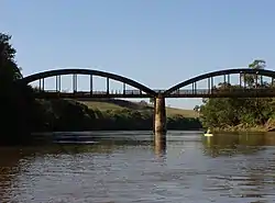 Bridge connecting Cordislândia-MG to Machado-MG | |
 Flag  Seal | |
| Country | |
| Region | Southeast |
| State | Minas Gerais |
| Mesoregion | Oeste de Minas |
| Government | |
| • Mayor | Julert Ferri (PMDB) |
| Population (2020 [1]) | |
| • Total | 42,413 |
| Time zone | UTC−3 (BRT) |
Machado is a municipality in the state of Minas Gerais in the Southeast region of Brazil.[2][3][4][5]
See also
References
- ↑ IBGE 2020
- ↑ "Divisão Territorial do Brasil" (in Portuguese). Divisão Territorial do Brasil e Limites Territoriais, Instituto Brasileiro de Geografia e Estatística (IBGE). July 1, 2008. Retrieved December 17, 2009.
- ↑ "Estimativas da população para 1º de julho de 2009" (PDF) (in Portuguese). Estimativas de População, Instituto Brasileiro de Geografia e Estatística (IBGE). August 14, 2009. Retrieved December 17, 2009.
- ↑ "Ranking decrescente do IDH-M dos municípios do Brasil" (in Portuguese). Atlas do Desenvolvimento Humano, Programa das Nações Unidas para o Desenvolvimento (PNUD). 2000. Archived from the original on October 3, 2009. Retrieved December 17, 2009.
- ↑ "Produto Interno Bruto dos Municípios 2002-2005" (PDF) (in Portuguese). Instituto Brasileiro de Geografia e Estatística (IBGE). December 19, 2007. Archived from the original (PDF) on October 2, 2008. Retrieved December 17, 2009.

21°40′30″S 45°55′12″W / 21.675°S 45.92°W
This article is issued from Wikipedia. The text is licensed under Creative Commons - Attribution - Sharealike. Additional terms may apply for the media files.