Timóteo | |
|---|---|
Municipality | |
| Municipality of Timóteo | |
 Partial view of Timóteo seen from the Primavera neighborhood | |
 Flag  Seal | |
| Nickname(s): "A Capital do Inox" | |
 | |
| Country | |
| Region | Southeast |
| State | |
| Founded | April 29, 1964 |
| Area | |
| • Total | 144.381 km2 (55.746 sq mi) |
| Population (2020 [1]) | |
| • Total | 90,568 |
| • Density | 611.26/km2 (1,583.2/sq mi) |
| Time zone | UTC−3 (BRT) |
| HDI (2010) | 0,770 – high |
| Website | http://www.timoteo.mg.gov.br/ |
Timóteo is a Brazilian municipality in the state of Minas Gerais, located by the Piracicaba River. The population as of 2020 was 90,568 inhabitants. The city is situated in the metropolitan area of the Steel Valley (Vale do Aço). It is the hometown of Aperam South America (old Acesita), a steel factory specialized in the production of stainless steel, now named Aperam.
The municipality contains part of the 35,970 hectares (88,900 acres) Rio Doce State Park, created in 1944, the first state-level conservation unit in Minas Gerais.[2]
 Aperam South America's central headquarter
 Sinergia Monument
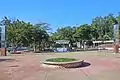 1º de Maio (1 May) Square, in the Centro-Norte (North-Central).
 Saint Joseph the Worker church (North-Central)
 29 de Abril (29 Abril) Square, in the Centro-Sul (South-Central).
 Saint Sebastian Mother Church (South-Central)
External links
References
- ↑ IBGE 2020
- ↑ Parque Estadual do Rio Doce (in Portuguese), IEF: Instituto Estadual de Florestas MG, retrieved 2017-02-06
19°34′58″S 42°38′38″W / 19.58278°S 42.64389°W

This article is issued from Wikipedia. The text is licensed under Creative Commons - Attribution - Sharealike. Additional terms may apply for the media files.