| Manupeu Tanah Daru National Park | |
|---|---|
| Taman Nasional Manupeu Tanah Daru | |
 Lapopu waterfall in Manupeu Tanah Daru National Park | |
 Manupeu Tanah Daru NP | |
| Location | Sumba, Indonesia |
| Coordinates | 9°44′0″S 119°41′0″E / 9.73333°S 119.68333°E |
| Area | 87,984.09 ha |
| Established | 1998 |
| Governing body | Ministry of Forestry |
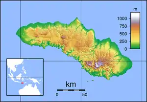
Manupeu Tanah Daru National Park is located on the island of Sumba in Indonesia. This national park consists lowland forests on steep slopes that rise up to ca. 600m.[1]
Flora and fauna
There are about 118 plant species protected in this national park including Toona sureni, Sterculia foetida, Schleichera oleosa, Alstonia scholaris (ditabark), Tamarind, candlenut, Syzygium species, Casuarina species, and Lantana camara (Spanish flag).[1]
There are also 87 species of birds protected in this region, with 7 bird taxa endemic to the island of Sumba. These are Sumba yellow-crested cockatoo, Sumba green pigeon, Sumba flycatcher, Sumba cicadabird, apricot-breasted sunbird and Sumba hornbill.
57 species of butterflies are also protected here, 7 of them are endemic to this island. These are Papilio neumoegenii, Ideopsis oberthurii, Delias fasciata, Junonia adulatrix, Athyma karita, Sumalia chilo, and Elimnia amoena.
See also
References
- 1 2 Ministry of Forestry of Indonesia: "Manupeu-Tanah Daru National Park" Archived 2014-12-18 at the Wayback Machine, retrieved 4 December 2013