Masuda
益田市 | |
|---|---|
 Masuda City Hall | |
 Flag  Emblem | |
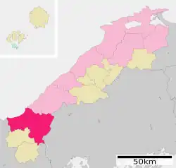
Location of Masuda in Shimane Prefecture | |
 | |
 Masuda Location in Japan | |
| Coordinates: 34°40′29″N 131°50′34″E / 34.67472°N 131.84278°E | |
| Country | Japan |
| Region | Chūgoku (San'in) |
| Prefecture | Shimane |
| Government | |
| • Mayor | Shintaro Fukuhara (since August 2008) |
| Area | |
| • Total | 733.19 km2 (283.09 sq mi) |
| Population (July 31, 2023) | |
| • Total | 43,885 |
| • Density | 60/km2 (160/sq mi) |
| Time zone | UTC+09:00 (JST) |
| City hall address | 1-1, Tokiwa-chō, Masuda-shi, Shimane-ken 698-8650 |
| Climate | Cfa |
| Website | Official website |
| Symbols | |
| Flower | Narcissus |
| Tree | Keyaki |
.jpg.webp)


Masuda (益田市, Masuda-shi) is a city located in Shimane Prefecture, Japan. As of 31 July 2023, the city had an estimated population of 43,885 in 21249 households and a population density of 60 persons per km².[1] The total area of the city is 733.19 square kilometres (283.09 sq mi).
Geography
Masuda is located on the western edge of Honshu, facing the Sea of Japan to the north and the Chugoku Mountains to the south and is bordered by Yamaguchi Prefecture to the west and Hiroshima Prefecture to the southwest. The city has the largest geographic area among municipalities in Shimane Prefecture. The urban center is on a narrow floodplain between the Takatsu River and the Masuda River. Parts of the southern region of the city are within the borders of the Nishi-Chugoku Sanchi Quasi-National Park.
Neighboring municipalities
Shimane Prefecture
Yamaguchi Prefecture
Hiroshima Prefecture
Climate
Masuda has a humid subtropical climate (Köppen climate classification Cfa) with very warm summers and cool winters. Precipitation is abundant throughout the year. The average annual temperature in Masuda is 15.9 °C (60.6 °F). The average annual rainfall is 1,570.5 mm (61.83 in) with July as the wettest month. The temperatures are highest on average in August, at around 27.6 °C (81.7 °F), and lowest in January, at around 5.5 °C (41.9 °F).[2] The highest temperature ever recorded in Masuda was 39.3 °C (102.7 °F) on 6 August 2017; the coldest temperature ever recorded was −7.3 °C (18.9 °F) on 26 February 1981.[3]
| Climate data for Masuda (1991−2020 normals, extremes 1978−present) | |||||||||||||
|---|---|---|---|---|---|---|---|---|---|---|---|---|---|
| Month | Jan | Feb | Mar | Apr | May | Jun | Jul | Aug | Sep | Oct | Nov | Dec | Year |
| Record high °C (°F) | 20.4 (68.7) |
24.1 (75.4) |
26.6 (79.9) |
31.7 (89.1) |
32.4 (90.3) |
35.9 (96.6) |
37.9 (100.2) |
39.3 (102.7) |
37.4 (99.3) |
33.7 (92.7) |
27.4 (81.3) |
25.3 (77.5) |
39.3 (102.7) |
| Mean daily maximum °C (°F) | 9.3 (48.7) |
10.3 (50.5) |
13.7 (56.7) |
18.8 (65.8) |
23.5 (74.3) |
26.4 (79.5) |
30.7 (87.3) |
32.2 (90.0) |
27.9 (82.2) |
22.8 (73.0) |
17.5 (63.5) |
11.9 (53.4) |
20.4 (68.7) |
| Daily mean °C (°F) | 5.5 (41.9) |
6.1 (43.0) |
8.9 (48.0) |
13.7 (56.7) |
18.4 (65.1) |
22.1 (71.8) |
26.5 (79.7) |
27.6 (81.7) |
23.3 (73.9) |
17.7 (63.9) |
12.6 (54.7) |
7.8 (46.0) |
15.9 (60.5) |
| Mean daily minimum °C (°F) | 1.9 (35.4) |
1.9 (35.4) |
4.0 (39.2) |
8.4 (47.1) |
13.3 (55.9) |
18.2 (64.8) |
23.0 (73.4) |
23.8 (74.8) |
19.3 (66.7) |
13.1 (55.6) |
8.2 (46.8) |
4.0 (39.2) |
11.6 (52.9) |
| Record low °C (°F) | −5.1 (22.8) |
−7.3 (18.9) |
−2.5 (27.5) |
−1.9 (28.6) |
3.4 (38.1) |
8.7 (47.7) |
13.6 (56.5) |
16.3 (61.3) |
7.4 (45.3) |
2.9 (37.2) |
0.2 (32.4) |
−2.3 (27.9) |
−7.3 (18.9) |
| Average precipitation mm (inches) | 97.0 (3.82) |
80.5 (3.17) |
121.4 (4.78) |
109.8 (4.32) |
124.4 (4.90) |
179.8 (7.08) |
238.2 (9.38) |
136.0 (5.35) |
169.6 (6.68) |
107.6 (4.24) |
96.5 (3.80) |
109.8 (4.32) |
1,570.5 (61.83) |
| Average precipitation days (≥ 1.0 mm) | 13.2 | 12.2 | 12.5 | 10.4 | 9.4 | 11.4 | 10.9 | 8.8 | 10.1 | 8.7 | 10.3 | 13.5 | 131.4 |
| Mean monthly sunshine hours | 74.5 | 99.4 | 156.3 | 191.9 | 213.9 | 160.9 | 182.9 | 215.4 | 164.2 | 170.0 | 121.4 | 81.2 | 1,840.6 |
| Source: Japan Meteorological Agency[3][2] | |||||||||||||
| Climate data for Iwami Airport, Masuda (2003−2020 normals, extremes 2003−present) | |||||||||||||
|---|---|---|---|---|---|---|---|---|---|---|---|---|---|
| Month | Jan | Feb | Mar | Apr | May | Jun | Jul | Aug | Sep | Oct | Nov | Dec | Year |
| Record high °C (°F) | 18.8 (65.8) |
23.1 (73.6) |
25.8 (78.4) |
30.6 (87.1) |
30.7 (87.3) |
34.4 (93.9) |
35.0 (95.0) |
36.3 (97.3) |
35.7 (96.3) |
32.1 (89.8) |
26.5 (79.7) |
24.1 (75.4) |
36.3 (97.3) |
| Mean daily maximum °C (°F) | 8.7 (47.7) |
9.9 (49.8) |
13.0 (55.4) |
17.7 (63.9) |
22.1 (71.8) |
24.8 (76.6) |
29.0 (84.2) |
30.4 (86.7) |
26.5 (79.7) |
21.7 (71.1) |
16.9 (62.4) |
11.1 (52.0) |
19.3 (66.8) |
| Daily mean °C (°F) | 5.0 (41.0) |
5.8 (42.4) |
8.5 (47.3) |
13.0 (55.4) |
17.5 (63.5) |
21.1 (70.0) |
25.3 (77.5) |
26.4 (79.5) |
22.5 (72.5) |
17.2 (63.0) |
12.4 (54.3) |
7.2 (45.0) |
15.2 (59.3) |
| Mean daily minimum °C (°F) | 1.6 (34.9) |
1.8 (35.2) |
3.9 (39.0) |
8.2 (46.8) |
13.0 (55.4) |
17.9 (64.2) |
22.3 (72.1) |
23.2 (73.8) |
19.0 (66.2) |
13.1 (55.6) |
8.3 (46.9) |
3.7 (38.7) |
11.3 (52.4) |
| Record low °C (°F) | −5.2 (22.6) |
−4.4 (24.1) |
−2.2 (28.0) |
−1.6 (29.1) |
4.2 (39.6) |
10.2 (50.4) |
15.3 (59.5) |
15.4 (59.7) |
11.1 (52.0) |
5.5 (41.9) |
0.5 (32.9) |
−2.4 (27.7) |
−5.2 (22.6) |
| Average precipitation mm (inches) | 79.1 (3.11) |
78.3 (3.08) |
113.3 (4.46) |
113.9 (4.48) |
111.0 (4.37) |
160.4 (6.31) |
252.3 (9.93) |
141.0 (5.55) |
171.4 (6.75) |
114.5 (4.51) |
82.9 (3.26) |
115.0 (4.53) |
1,533 (60.35) |
| Average precipitation days (≥ 1.0 mm) | 11.6 | 10.6 | 11.7 | 10.1 | 7.9 | 10.3 | 11.5 | 9.1 | 10.4 | 8.4 | 9.4 | 13.3 | 124.3 |
| Source: Japan Meteorological Agency[4][5] | |||||||||||||
Demographics
Per Japanese census data, the population of Masuda in 2020 is 45,003 people.[6] Masuda has been conducting censuses since 1920.
| Year | Pop. | ±% |
|---|---|---|
| 1920 | 52,185 | — |
| 1925 | 53,767 | +3.0% |
| 1930 | 54,962 | +2.2% |
| 1935 | 57,150 | +4.0% |
| 1940 | 56,877 | −0.5% |
| 1945 | 66,488 | +16.9% |
| 1950 | 68,219 | +2.6% |
| 1955 | 72,991 | +7.0% |
| 1960 | 70,018 | −4.1% |
| 1965 | 63,337 | −9.5% |
| 1970 | 58,308 | −7.9% |
| 1975 | 57,727 | −1.0% |
| 1980 | 59,040 | +2.3% |
| 1985 | 60,080 | +1.8% |
| 1990 | 57,706 | −4.0% |
| 1995 | 56,596 | −1.9% |
| 2000 | 54,622 | −3.5% |
| 2005 | 52,368 | −4.1% |
| 2010 | 49,925 | −4.7% |
| 2015 | 47,718 | −4.4% |
| 2020 | 45,003 | −5.7% |
| Masuda population statistics[6] | ||
History
The area of Masuda was part of ancient Iwami Province, and corresponds almost exactly with Mino District, which is mentioned from the Nara period onwards. The area was controlled by the Masuda clan from the Kamakura period to the end of the Sengoku period. During the Edo Period, the area was divided between the holdings of Tsuwano Domain and Hamada Domain. After the Meiji restoration, the town of Masuda was established on April 1, 1889 with the creation of the modern municipalities system. The city was founded on August 1, 1952 by the merger of Masuda with seven neighbouring villages. On November 1, 2004, the towns of Mito and Hikimi (both from Mino District) were merged into Masuda. Mino District was dissolved as a result of this merger.
Government
Masuda has a mayor-council form of government with a directly elected mayor and a unicameral city council of 22 members. Masuda conributes three members to the Shimane Prefectural Assembly. In terms of national politics, the city is part of the Shimane 2nd district of the lower house of the Diet of Japan.
Economy
The main industries in Masuda are agriculture and commercial fishing, agriculture. Manufacturing includes textiles and electronic components.
Education
Masuda has 15 public elementary school and ten public junior high schools operated by the city government, and two public high schools operated by the Shimane Prefectural Board of Education. There are also two private high schools, and the prefecture operates one special education school for the handicapped.
Transportation
Airport
Railway
![]() JR West (JR West) - San'in Main Line
JR West (JR West) - San'in Main Line
- Kamate - Iwami-Tsuda - Masuda - Todakohama - Iinoura
![]() JR West (JR West) - Yamaguchi Line
JR West (JR West) - Yamaguchi Line
Highways
Sister cities / Friendship cities
 Ningbo, China (since October 1990)
 Queenstown, New Zealand
Local attractions
- Ikō-ji, National Historic Site and National Place of Scenic Beauty
- Manpuku-ji, National Historic Site and National Place of Scenic Beauty
- Nanao Castle ruins, National Historic Site
- Nakazu-Higashihara Site, National Historic Site
- Sukumozuka Kofun, National Historic Site
- Ōmoto Kofun, National Historic Site
- Sesshū Memorial Museum
- Iwami Art Museum
- Shimane Prefectural Manyō Park
References
- ↑ "Masuda City official statistics" (in Japanese). Japan.
- 1 2 気象庁 / 平年値(年・月ごとの値). JMA. Retrieved April 26, 2022.
- 1 2 観測史上1~10位の値(年間を通じての値). JMA. Retrieved April 26, 2022.
- ↑ 観測史上1~10位の値(年間を通じての値). JMA. Retrieved April 26, 2022.
- ↑ 気象庁 / 平年値(年・月ごとの値). JMA. Retrieved April 26, 2022.
- 1 2 Masuda population statistics
External links
 Media related to Masuda, Shimane at Wikimedia Commons
- Masuda City official website (in Japanese)
- Masuda City official website (in English)