Municipality of Dolenjske Toplice
Občina Dolenjske Toplice | |
|---|---|
 | |
 Coat of arms | |
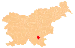
 Location of the Municipality of Dolenjske Toplice in Slovenia | |
| Coordinates: 45°45′N 15°03′E / 45.750°N 15.050°E | |
| Country | |
| Government | |
| • Mayor | Jože Muhič |
| Area | |
| • Total | 110.2 km2 (42.5 sq mi) |
| Population (2002)[1] | |
| • Total | 3,298 |
| • Density | 30/km2 (78/sq mi) |
| Time zone | UTC+01 (CET) |
| • Summer (DST) | UTC+02 (CEST) |
| Website | www |
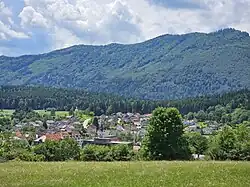
The Municipality of Dolenjske Toplice (Slovene: Občina Dolenjske Toplice; pronounced [ˈóːptʃina dɔˈleːnskɛ tɔˈpliːtsɛ]) is a municipality near Novo Mesto in southeastern Slovenia. Its seat is the town of Dolenjske Toplice. The area is part of the traditional region of Lower Carniola. The municipality is now included in the Southeast Slovenia Statistical Region.[2]
Settlements
In addition to the municipal seat of Dolenjske Toplice, the municipality also includes the following settlements:
- Bušinec
- Cerovec
- Dobindol
- Dolenje Gradišče
- Dolenje Polje
- Dolenje Sušice
- Drenje
- Gabrje pri Soteski
- Gorenje Gradišče
- Gorenje Polje
- Gorenje Sušice
- Kočevske Poljane
- Loška Vas
- Mali Rigelj
- Meniška Vas
- Nova Gora
- Občice
- Obrh
- Podhosta
- Podstenice
- Podturn pri Dolenjskih Toplicah
- Sela pri Dolenjskih Toplicah
- Selišče
- Soteska
- Stare Žage
- Suhor pri Dolenjskih Toplicah
- Veliki Rigelj
- Verdun pri Uršnih Selih
References
External links
 Media related to Municipality of Dolenjske Toplice at Wikimedia Commons
- Municipality of Dolenjske Toplice on Geopedia
- Dolenjske Toplice municipal site
This article is issued from Wikipedia. The text is licensed under Creative Commons - Attribution - Sharealike. Additional terms may apply for the media files.
