Municipality of Dornava
Občina Dornava | |
|---|---|
 | |
 Coat of arms | |
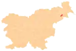
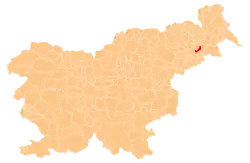 Location of the Municipality of Dornava in Slovenia | |
| Coordinates: 46°26′N 15°57′E / 46.433°N 15.950°E | |
| Country | |
| Government | |
| • Mayor | Rajko Janžekovič |
| Area | |
| • Total | 28.4 km2 (11.0 sq mi) |
| Population (2002)[1] | |
| • Total | 2,459 |
| • Density | 87/km2 (220/sq mi) |
| Time zone | UTC+01 (CET) |
| • Summer (DST) | UTC+02 (CEST) |
| Website | www |
The Municipality of Dornava (pronounced [ˈdoːɾnaʋa]; Slovene: Občina Dornava) is a small municipality in northeastern Slovenia. It lies east of Ptuj, partly on the Pesnica River and partly in the Slovene Hills (Slovene: Slovenske gorice). The seat of the municipality is the settlement of Dornava. The area is part of the traditional region of Styria. The municipality is now included in the Drava Statistical Region.[2]
Settlements
In addition to the municipal seat of Dornava, the municipality also includes the following settlements:
Gallery
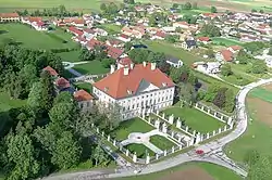
_18._Jh%252C_Einfahrt.jpg.webp) Dornava Mansion, built in 1753
Dornava Mansion, built in 1753
References
External links
 Media related to Municipality of Dornava at Wikimedia Commons
- Municipality of Dornava on Geopedia
- Dornava municipal site
| Settlements | Administrative seat: Dornava
|  |
|---|---|---|
| Landmarks |
| |
This article is issued from Wikipedia. The text is licensed under Creative Commons - Attribution - Sharealike. Additional terms may apply for the media files.