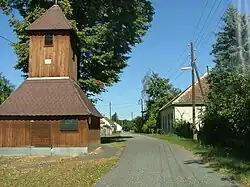
Nemesrempehollós | |
|---|---|
Village | |
 | |
 Flag  Coat of arms | |
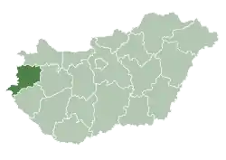
 Nemesrempehollós Location of Nemesrempehollós | |
| Coordinates: 47°05′39″N 16°40′56″E / 47.09412°N 16.68220°E | |
| Country | Hungary |
| Region | Western Transdanubia |
| County | Vas |
| District | Körmend |
| Area | |
| • Total | 12.05 km2 (4.65 sq mi) |
| Population (1 January 2023)[1] | |
| • Total | 255 |
| • Density | 21/km2 (55/sq mi) |
| Time zone | UTC+1 (CET) |
| • Summer (DST) | UTC+2 (CEST) |
| Postal code | 9782 |
| Area code | (+36) 94 |
| Website | radochollos |
References
- ↑ Error: Unable to display the reference properly. See the documentation for details.
External links
- Street map (in Hungarian)

This article is issued from Wikipedia. The text is licensed under Creative Commons - Attribution - Sharealike. Additional terms may apply for the media files.