Ostrolovský Újezd | |
|---|---|
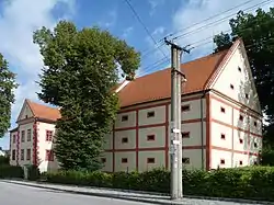 Ostrolovský Újezd Castle | |
 Ostrolovský Újezd Location in the Czech Republic | |
| Coordinates: 48°52′50″N 14°36′2″E / 48.88056°N 14.60056°E | |
| Country | |
| Region | South Bohemian |
| District | České Budějovice |
| First mentioned | 1381 |
| Area | |
| • Total | 3.83 km2 (1.48 sq mi) |
| Elevation | 471 m (1,545 ft) |
| Population (2023-01-01)[1] | |
| • Total | 174 |
| • Density | 45/km2 (120/sq mi) |
| Time zone | UTC+1 (CET) |
| • Summer (DST) | UTC+2 (CEST) |
| Postal code | 374 01 |
| Website | www |
Ostrolovský Újezd (until 1948 Újezd Ostrolov) is a municipality and village in České Budějovice District in the South Bohemian Region of the Czech Republic. It has about 200 inhabitants.
Ostrolovský Újezd lies approximately 14 kilometres (9 mi) south-east of České Budějovice and 135 km (84 mi) south of Prague.
References
Wikimedia Commons has media related to Ostrolovský Újezd.
This article is issued from Wikipedia. The text is licensed under Creative Commons - Attribution - Sharealike. Additional terms may apply for the media files.