Temelín | |
|---|---|
.jpg.webp) Temelín Nuclear Power Plant | |
 Flag  Coat of arms | |
 Temelín Location in the Czech Republic | |
| Coordinates: 49°11′34″N 14°20′56″E / 49.19278°N 14.34889°E | |
| Country | |
| Region | South Bohemian |
| District | České Budějovice |
| First mentioned | 1381 |
| Area | |
| • Total | 50.40 km2 (19.46 sq mi) |
| Elevation | 443 m (1,453 ft) |
| Population (2023-01-01)[1] | |
| • Total | 878 |
| • Density | 17/km2 (45/sq mi) |
| Time zone | UTC+1 (CET) |
| • Summer (DST) | UTC+2 (CEST) |
| Postal codes | 373 01, 375 01 |
| Website | www |
Temelín (German: Groß Temelin) is a municipality and village in České Budějovice District in the South Bohemian Region of the Czech Republic. It has about 900 inhabitants.
Administrative parts
Villages of Březí u Týna nad Vltavou, Knín, Kočín, Křtěnov, Lhota pod Horami, Litoradlice, Podhájí, Sedlec, Temelínec and Zvěrkovice are administrative parts of Temelín.
Economy
Temelín Nuclear Power Station, one of the two Czech nuclear power plants, is located in the municipality.
Gallery
_06.jpg.webp) Kočín
Kočín_02.jpg.webp) Chapel of Saint Procopius in Kočín
Chapel of Saint Procopius in Kočín Temelín pond
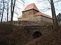 Býšov fortress in Knín
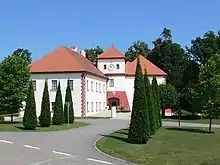 Vysoký Hrádek Castle
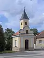 Chapel in Temelín
See also
- Dukovany, the second Czech municipality with a nuclear power station
References
External links
Wikimedia Commons has media related to Temelín.
This article is issued from Wikipedia. The text is licensed under Creative Commons - Attribution - Sharealike. Additional terms may apply for the media files.