Pavlov | |
|---|---|
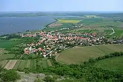 Aerial view | |
 Flag  Coat of arms | |
 Pavlov Location in the Czech Republic | |
| Coordinates: 48°52′27″N 16°40′20″E / 48.87417°N 16.67222°E | |
| Country | |
| Region | South Moravian |
| District | Břeclav |
| First mentioned | 1046 |
| Area | |
| • Total | 13.03 km2 (5.03 sq mi) |
| Elevation | 245 m (804 ft) |
| Population (2023-01-01)[1] | |
| • Total | 609 |
| • Density | 47/km2 (120/sq mi) |
| Time zone | UTC+1 (CET) |
| • Summer (DST) | UTC+2 (CEST) |
| Postal code | 692 01 |
| Website | www |
Pavlov (German: Pollau) is a municipality and village in Břeclav District in the South Moravian Region of the Czech Republic. It has about 600 inhabitants.
Geography
Pavlov is located about 20 kilometres (12 mi) northwest of Břeclav and 34 km (21 mi) south of Brno. It lies in the Mikulov Highlands. The village lies under the Děvín mountain, which is the highest mountain of the municipality and of the entire region with an elevation of 550 metres (1,800 ft). It is situated on the shore of the Nové Mlýny reservoirs. The municipality is located in the Pálava Protected Landscape Area.
See also
References
Wikimedia Commons has media related to Pavlov (Břeclav District).
This article is issued from Wikipedia. The text is licensed under Creative Commons - Attribution - Sharealike. Additional terms may apply for the media files.