Strachotín | |
|---|---|
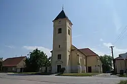 Church of Saints Ulrich, Cyril and Methodius | |
 Flag  Coat of arms | |
 Strachotín Location in the Czech Republic | |
| Coordinates: 48°54′20″N 16°39′5″E / 48.90556°N 16.65139°E | |
| Country | |
| Region | South Moravian |
| District | Břeclav |
| First mentioned | 1046 |
| Area | |
| • Total | 14.14 km2 (5.46 sq mi) |
| Elevation | 170 m (560 ft) |
| Population (2023-01-01)[1] | |
| • Total | 791 |
| • Density | 56/km2 (140/sq mi) |
| Time zone | UTC+1 (CET) |
| • Summer (DST) | UTC+2 (CEST) |
| Postal code | 693 01 |
| Website | www |
Strachotín is a municipality and village in Břeclav District in the South Moravian Region of the Czech Republic. It has about 800 inhabitants.
Geography
Strachotín is located about 23 kilometres (14 mi) northwest of Břeclav and 31 km (19 mi) south of Brno. It lies in the northwestern tip of the Lower Morava Valley. It is situated on the shores of the Nové Mlýny Reservoir and Strachotínský Pond.
History
The first written mention of Strachotín is from 1046. In 1334, it was promoted to a market town. During the Thirty Years' War, Strachotín was completely burned down. After the World War II, the municipality lost its market town title.[2]
References
- ↑ "Population of Municipalities – 1 January 2023". Czech Statistical Office. 2023-05-23.
- ↑ "Historie" (in Czech). Obec Strachotín. Retrieved 2021-11-27.
Wikimedia Commons has media related to Strachotín.
This article is issued from Wikipedia. The text is licensed under Creative Commons - Attribution - Sharealike. Additional terms may apply for the media files.