Perná | |
|---|---|
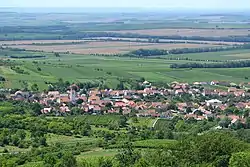 View from the northeast | |
 Flag  Coat of arms | |
 Perná Location in the Czech Republic | |
| Coordinates: 48°51′8″N 16°37′28″E / 48.85222°N 16.62444°E | |
| Country | |
| Region | South Moravian |
| District | Břeclav |
| First mentioned | 1305 |
| Area | |
| • Total | 9.33 km2 (3.60 sq mi) |
| Elevation | 228 m (748 ft) |
| Population (2023-01-01)[1] | |
| • Total | 805 |
| • Density | 86/km2 (220/sq mi) |
| Time zone | UTC+1 (CET) |
| • Summer (DST) | UTC+2 (CEST) |
| Postal code | 691 86 |
| Website | www |
Perná is a municipality and village in Břeclav District in the South Moravian Region of the Czech Republic. It has about 800 inhabitants.
Perná lies approximately 22 kilometres (14 mi) north-west of Břeclav, 39 km (24 mi) south of Brno, and 210 km (130 mi) south-east of Prague.
References
Wikimedia Commons has media related to Perná.
This article is issued from Wikipedia. The text is licensed under Creative Commons - Attribution - Sharealike. Additional terms may apply for the media files.