| River Cong | |
|---|---|
.JPG.webp) River Cong | |
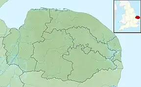
 Location of the river mouth within Norfolk | |
| Location | |
| Country | England |
| State | Norfolk |
| Region | East of England |
| District | King's Lynn and West Norfolk |
| Physical characteristics | |
| Source | |
| • location | Manor Farm, Congham |
| • coordinates | 52°47′11″N 0°33′00″E / 52.7865°N 0.5499°E |
| • elevation | 19 m (62 ft) |
| Mouth | River Babingley |
• location | west of Hillington |
• coordinates | 52°48′02″N 0°31′52″E / 52.8006°N 0.5311°E |
• elevation | 13 m (43 ft) |
| Length | 1.5 mi (2.4 km) |
| Basin features | |
| River system | River Babingley |
The River Cong is a stream in the west of the county of Norfolk, only 1.5 miles (2.4 km) in length.[1] It is a tributary of the River Babingley. The spring rises in a meadow pool on the Hillington side of Manor Farm, Congham. From there, it flows through the wood and over a small waterfall, where in the past it powered all the machinery within the Congham Oil Mill (grid reference TF71342475), which is now known as Congham Lodge.[2]
.JPG.webp)
.JPG.webp)
The name of the stream does not appear on current Ordnance Survey maps, and few sources name it. One appearance of the name is in the neighbouring village of Congham, whose name is listed by one source as meaning "dwelling by the River Cong",[3] though more recent sources suggest a possible direct meaning of dwelling "at the hill".[4]
Congham Oil Mill
The mill is said to have been built for processing whales. Whales were transported from King's Lynn docks by horse and wagon. The mill produced oil from whale blubber. The resultant whale bones were then taken by road to Narborough Bone Mill where they were ground into fertiliser. Some of the whale bones remain as ornaments at Congham Lodge to this day. The waterfall that drove the mill still remains. There would have been a horrendous smell especially in the summer, which was why the mill was situated away from King's Lynn itself. The Cong then flows on under the A148 and joins the Babingley close by the Gatton Waters caravan site.
See also
References
- ↑ "The River Babingley" (PDF). Norfolk Biodiversity Information Service. May 2014.
- ↑ Ordnance Survey (2002). OS Explorer Map 250 – Norfolk Coast West. ISBN 0-319-21886-4.
- ↑ J Chambers (1829). A general history of the county of Norfolk, intended to convey all the information of a Norfolk tour. p. 394.
- ↑ A. D. Mills. A Dictionary of British Place Names. Oxford University Press.