Sainte-Foy | |
|---|---|
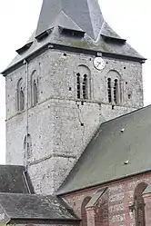 The church in Sainte-Foy | |
Location of Sainte-Foy | |
 Sainte-Foy  Sainte-Foy | |
| Coordinates: 49°47′47″N 1°08′10″E / 49.7964°N 1.1361°E | |
| Country | France |
| Region | Normandy |
| Department | Seine-Maritime |
| Arrondissement | Dieppe |
| Canton | Luneray |
| Intercommunality | CC Terroir de Caux |
| Government | |
| • Mayor (2020–2026) | David Chandelier[1] |
| Area 1 | 6.72 km2 (2.59 sq mi) |
| Population | 625 |
| • Density | 93/km2 (240/sq mi) |
| Time zone | UTC+01:00 (CET) |
| • Summer (DST) | UTC+02:00 (CEST) |
| INSEE/Postal code | 76577 /76590 |
| Elevation | 65–154 m (213–505 ft) (avg. 135 m or 443 ft) |
| 1 French Land Register data, which excludes lakes, ponds, glaciers > 1 km2 (0.386 sq mi or 247 acres) and river estuaries. | |
Sainte-Foy (French pronunciation: [sɛ̃t fwa]) is a commune in the Seine-Maritime department in the Normandy region in northern France.
Geography
A farming village situated in the Pays de Caux, some 9 miles (14 km) south of Dieppe at the junction of the D100 and the D149 roads.
Population
| Year | Pop. | ±% p.a. |
|---|---|---|
| 1968 | 311 | — |
| 1975 | 378 | +2.83% |
| 1982 | 438 | +2.13% |
| 1990 | 405 | −0.97% |
| 1999 | 390 | −0.42% |
| 2007 | 491 | +2.92% |
| 2012 | 564 | +2.81% |
| 2017 | 593 | +1.01% |
| Source: INSEE[3] | ||
Places of interest
- The church of St. Foy, dating from the eleventh century.
- An eleventh-century chapel.
- The château and its park.
See also
References
- ↑ Liste des maires du département de la Seine-Maritime, 10 August 2020
- ↑ "Populations légales 2021". The National Institute of Statistics and Economic Studies. 28 December 2023.
- ↑ Population en historique depuis 1968, INSEE
Wikimedia Commons has media related to Sainte-Foy (Seine-Maritime).
This article is issued from Wikipedia. The text is licensed under Creative Commons - Attribution - Sharealike. Additional terms may apply for the media files.