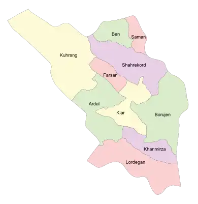
Shahrekord County
Persian: شهرستان شهرکرد | |
|---|---|
County | |
 Location of Shahrekord County in Chaharmahal and Bakhtiari province (top, purple) | |
 Location of Chaharmahal and Bakhtiari province in Iran | |
| Coordinates: 32°19′N 50°47′E / 32.317°N 50.783°E[1] | |
| Country | |
| Province | Chaharmahal and Bakhtiari |
| Capital | Shahr-e Kord |
| Districts | Central, Farrokhshahr, Laran |
| Population (2016)[2] | |
| • Total | 315,980 |
| Time zone | UTC+3:30 (IRST) |
| Shahrekord County can be found at GEOnet Names Server, at this link, by opening the Advanced Search box, entering "9206270" in the "Unique Feature Id" form, and clicking on "Search Database". | |
Shahrekord County (Persian: شهرستان شهرکرد) is in Chaharmahal and Bakhtiari province, Iran. Its capital is the city of Shahr-e Kord.[3]
At the 2006 census, the county's population was 362,381 in 91,273 households.[4] The following census in 2011 counted 340,382 people in 95,406 households,[5] by which time Kiar District had been separated from the county in the establishment of Kiar County.[6] At the 2016 census, the county's population was 315,980 in 93,104 households,[2] by which time Ben District had been separated from the county in the establishment of Ben County, and Saman District to become Saman County.[7]
Administrative divisions
The population history and structural changes of Shahrekord County's administrative divisions over three consecutive censuses are shown in the following table. The latest census shows three districts, six rural districts, and nine cities.[2]
| Administrative Divisions | 2006[4] | 2011[5] | 2016[2] |
|---|---|---|---|
| Central District | 224,380 | 242,215 | 246,046 |
| Howmeh RD | 23,397 | 3,888 | 5,360 |
| Taqanak RD | 5,035 | 5,733 | 5,716 |
| Farrokh Shahr (city) | 28,920 | 30,036 | |
| Hafshejan (city) | 20,042 | 20,847 | 21,352 |
| Kian (city) | 10,922 | 12,020 | 12,948 |
| Nafech (city) | 3,814 | 3,975 | 4,059 |
| Shahr-e Kord (city) | 126,746 | 159,775 | 190,441 |
| Taqanak (city) | 5,504 | 5,941 | 6,170 |
| Ben District1 | 27,731 | 29,481 | |
| Vardanjan RD | 11,014 | 8,549 | |
| Zayandeh Rud-e Jonubi RD | 5,018 | 4,833 | |
| Ben (city) | 11,699 | 11,775 | |
| Vardanjan (city) | 4,324 | ||
| Farrokhshahr District | 37,068 | ||
| Dastgerd RD | 4,350 | ||
| Qahfarrokh RD | 979 | ||
| Farrokh Shahr (city) | 31,739 | ||
| Kiar District2 | 43,108 | ||
| Dastgerd RD | 6,120 | ||
| Kiar-e Gharbi RD | 15,352 | ||
| Kiar-e Sharqi RD | 8,540 | ||
| Gahru (city) | 6,093 | ||
| Shalamzar (city) | 7,003 | ||
| Laran District | 32,705 | 32,791 | 32,863 |
| Lar RD | 13,824 | 13,877 | 9,075 |
| Margh Malek RD | 2,342 | 2,097 | 2,298 |
| Haruni (city) | 3,601 | ||
| Sudjan (city) | 5,415 | 5,410 | 5,581 |
| Sureshjan (city) | 11,124 | 11,407 | 12,308 |
| Saman District3 | 34,457 | 35,895 | |
| Hureh RD | 10,280 | 10,483 | |
| Saman RD | 9,400 | 10,085 | |
| Saman (city) | 14,777 | 15,327 | |
| Total | 362,381 | 340,382 | 315,980 |
| RD: Rural District 1Became a part of Ben County[7] 2Became a part of Kiar County[6] 3Became a part of Saman County[7] | |||
References
- ↑ OpenStreetMap contributors (2 April 2023). "Shahrekord County" (Map). OpenStreetMap. Retrieved 2 April 2023.
- 1 2 3 4 "Census of the Islamic Republic of Iran, 1395 (2016)". AMAR (in Persian). The Statistical Center of Iran. p. 14. Archived from the original (Excel) on 24 May 2019. Retrieved 19 December 2022.
- ↑ Habibi, Hassan (21 June 1369). "Approval of the organization and chain of citizenship of the elements and units of the national divisions of Chaharmahal and Bakhtiari province, centered in the city of Shahrekord". Islamic Parliament Research Center (in Persian). Ministry of Interior, Defense Political Commission of the Government Board. Archived from the original on 21 September 2016. Retrieved 2 December 2023.
- 1 2 "Census of the Islamic Republic of Iran, 1385 (2006)". AMAR (in Persian). The Statistical Center of Iran. p. 14. Archived from the original (Excel) on 20 September 2011. Retrieved 25 September 2022.
- 1 2 "Census of the Islamic Republic of Iran, 1390 (2011)". Syracuse University (in Persian). The Statistical Center of Iran. p. 14. Archived from the original (Excel) on 16 January 2023. Retrieved 19 December 2022.
- 1 2 Davodi, Parviz (18 September 1386). "Reforms of country divisions in Chaharmahal and Bakhtiari province". Qavanin (in Persian). Ministry of Interior, Political and Defense Commission. Archived from the original on 15 August 2023. Retrieved 6 November 2023.
- 1 2 3 Rahimi, Mohammad Reza (29 September 2013). "Letter of approval regarding country divisions in Chaharmahal and Bakhtiari province". Research Center of the System of Laws of the Islamic Council of Farabi Mobile Library (in Persian). Ministry of Interior, Council of Ministers. Archived from the original on 10 January 2013. Retrieved 6 November 2023.
