Template:Attached KML/TA postcode area
KML is from Wikidata
Taunton | |
|---|---|
 TA | |
| Coordinates: 51°03′22″N 3°04′12″W / 51.056°N 3.070°W | |
| Country | United Kingdom |
| Postcode area | TA |
| Postcode area name | Taunton |
| Post towns | 19 |
| Postcode districts | 24 |
| Postcode sectors | 67 |
| Postcodes (live) | 11,711 |
| Postcodes (total) | 14,693 |
| Statistics as at May 2020[1] | |
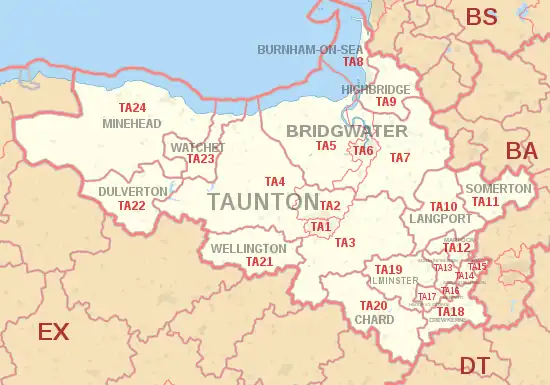
The TA postcode area, also known as the Taunton postcode area,[2] is a group of 24 postcode districts in South West England, within 19 post towns. These cover western Somerset (including Taunton, Bridgwater, Burnham-on-Sea, Chard, Crewkerne, Dulverton, Highbridge, Hinton St George, Ilminster, Langport, Martock, Merriott, Minehead, Montacute, Somerton, South Petherton, Stoke-sub-Hamdon, Watchet and Wellington), plus very small parts of Dorset and Devon.
Coverage
The approximate coverage of the postcode districts:
Map
Template:Attached KML/TA postcode area
KML is from Wikidata
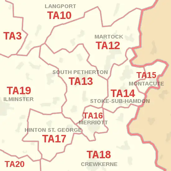
Detailed map of postcode districts and post towns in and around South Petherton
See also
References
- ↑ "ONS Postcode Directory Version Notes" (ZIP). National Statistics Postcode Products. Office for National Statistics. May 2020. Table 2. Retrieved 19 June 2020. Coordinates from mean of unit postcode points, "Code-Point Open". OS OpenData. Ordnance Survey. February 2012. Retrieved 21 April 2012.
- ↑ Royal Mail, Address Management Guide, (2004)
External links
This article is issued from Wikipedia. The text is licensed under Creative Commons - Attribution - Sharealike. Additional terms may apply for the media files.