Yozgat Province
Yozgat ili | |
|---|---|
 Sunset in Yozgat Fatih Nature Park | |
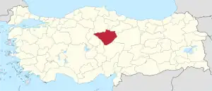 Location of the province within Turkey | |
| Country | Turkey |
| Seat | Yozgat |
| Government | |
| • Vali | adil şahin |
| Area | 13,690 km2 (5,290 sq mi) |
| Population (2022)[1] | 418,442 |
| • Density | 31/km2 (79/sq mi) |
| Time zone | TRT (UTC+3) |
| Area code | 0354 |
| Website | www |
Yozgat Province (Turkish: Yozgat ili) is a province in central Turkey. Its area is 13,690 km2,[2] and its population is 418,442 (2022).[1] Its adjacent provinces are Çorum to the northwest, Kırıkkale to the west, Kırşehir to the southwest, Nevşehir to the south, Kayseri to the southeast, Sivas to the east, Tokat to the northeast, and Amasya to the north. The provincial capital is Yozgat.
Toponymy
It was previously called Bozok and renamed Yozgat in 1927.
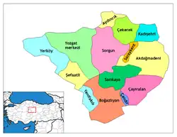
Districts

Yozgat province is divided into 14 districts (capital district in bold):
Places of interest
- Yozgat Pine Grove National Park
- Yozgat Castle (Historical Behramşah Castle and Tombs)
- Roma Kral Kızı Hamamı
- Yozgat Fatih Tabiat Parkı
- Büyük Camii (Çapanoğlu Mosque)
Mosques
- Fatih Camii, a former church in the city centre
- Yortanlı Sitesi, a former church in the city centre
See also
References
- 1 2 "Address-based population registration system (ADNKS) results dated 31 December 2022, Favorite Reports" (XLS). TÜİK. Retrieved 19 September 2023.
- ↑ "İl ve İlçe Yüz ölçümleri". General Directorate of Mapping. Retrieved 19 September 2023.
External links
![]() Media related to Yozgat Province at Wikimedia Commons
Media related to Yozgat Province at Wikimedia Commons
- (in Turkish) Yozgat official website
- (in Turkish) Yozgat governor's official website
- (in Turkish) Yozgat municipality's official website
- (in English) Yozgat weather forecast information
39°40′10″N 35°16′09″E / 39.66944°N 35.26917°E
This article is issued from Wikipedia. The text is licensed under Creative Commons - Attribution - Sharealike. Additional terms may apply for the media files.