Černilov | |
|---|---|
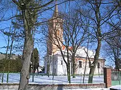 Evangelic church | |
 Flag  Coat of arms | |
 Černilov Location in the Czech Republic | |
| Coordinates: 50°15′45″N 15°55′25″E / 50.26250°N 15.92361°E | |
| Country | |
| Region | Hradec Králové |
| District | Hradec Králové |
| First mentioned | 1271 |
| Area | |
| • Total | 25.71 km2 (9.93 sq mi) |
| Elevation | 253 m (830 ft) |
| Population (2023-01-01)[1] | |
| • Total | 2,468 |
| • Density | 96/km2 (250/sq mi) |
| Time zone | UTC+1 (CET) |
| • Summer (DST) | UTC+2 (CEST) |
| Postal codes | 500 03, 503 03, 503 43, 503 46 |
| Website | www |
Černilov is a municipality and village in Hradec Králové District in the Hradec Králové Region of the Czech Republic. It has about 2,500 inhabitants.
Administrative parts
Villages of Bukovina and Újezd are administrative parts of Černilov.
Geography
Černilov is located about 7 kilometres (4 mi) northeast of Hradec Králové. It lies in an agricultural landscape of the Orlice Table. The highest point is at 287 m (942 ft) above sea level.
History
The first written mention of Černilov is from 1271. The village was founded on an old trade route.[2]
References
- ↑ "Population of Municipalities – 1 January 2023". Czech Statistical Office. 2023-05-23.
- ↑ "Historie obce" (in Czech). Obec Černilov. Retrieved 2022-09-03.
External links
Wikimedia Commons has media related to Černilov.
This article is issued from Wikipedia. The text is licensed under Creative Commons - Attribution - Sharealike. Additional terms may apply for the media files.